Moreton Bay, Redland & Redcliffe Peninsula Destination Guide
From Bribie Island to Cleveland Point — Queensland's Bayside Landscapes from Above
Bramble Bay
The Western Gateway to Moreton Bay
Bramble Bay forms the western section of Moreton Bay between the Redcliffe Peninsula and Brisbane's northern bayside suburbs.
This sheltered coastal environment is defined by:
-
tidal flats
-
mangrove wetlands
-
sandy shorelines
-
coastal parks
-
bridges and waterways
From above, Bramble Bay reveals a fascinating relationship between urban Brisbane and the natural marine environment.
The changing tides create constantly evolving patterns across the shallow waters, making the area particularly rewarding for aerial landscape photography.
Key visual features include:
-
Houghton Highway Bridge
-
Ted Smout Memorial Bridge
-
Clontarf shoreline
-
Redcliffe Peninsula
-
distant views toward Moreton Island
The contrast between infrastructure, coastline and open water creates unique photographic opportunities.
Woody Point
Seaside Village Views Across Moreton Bay
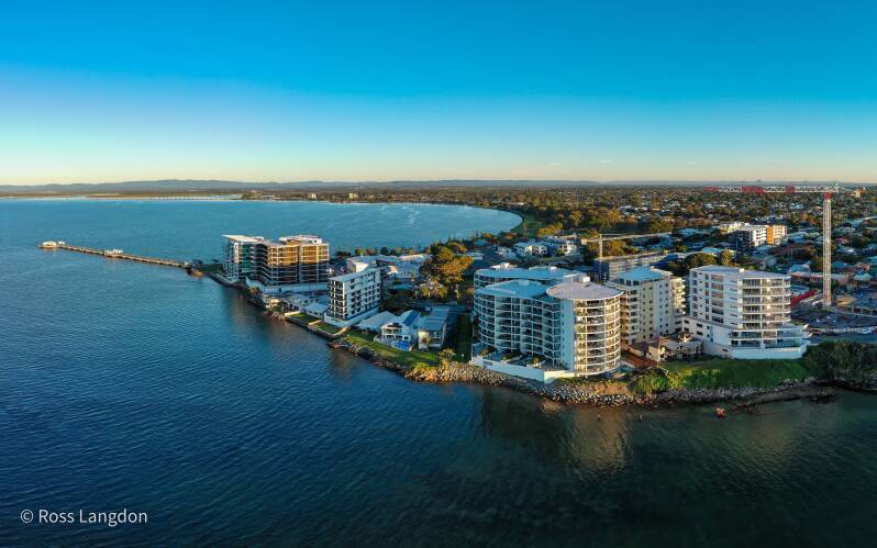
Located at the southern end of the Redcliffe Peninsula, Woody Point offers one of the most relaxed bayside environments in the region. The area is known for its waterfront atmosphere, coastal walks, jetty, parks and views across Moreton Bay.
From above, Woody Point showcases:
-
the sweeping peninsula shoreline
-
calm bay waters
-
waterfront parks
-
boating activity
-
views towards Moreton Island
Woody Point Jetty
The historic Woody Point Jetty is one of the area's most recognisable landmarks.
It creates excellent photographic compositions during:
-
sunrise
-
sunset
-
high tide reflections
-
calm weather conditions
The jetty extending into the bay provides strong leading lines, drawing the viewer toward the islands and horizon.
Clontarf
Bridges, Coastline and Bay Connections
Clontarf sits at the southern entrance to the Redcliffe Peninsula and forms an important connection between Brisbane and the bayside communities.
From an aerial perspective, Clontarf is defined by:
-
Ted Smout Memorial Bridge
-
Houghton Highway Bridge
-
coastal parks
-
boating channels
-
Bramble Bay views
The bridges create striking geometric patterns across the water and are especially impressive during golden hour and twilight photography.
Wellington Point
Islands, Sandbars and Tidal Landscapes
Wellington Point is one of the most visually distinctive locations on Brisbane's bayside.
The area is famous for its long coastal peninsula extending into Moreton Bay, providing views toward nearby islands and expansive tidal landscapes.
From above, Wellington Point reveals:
-
sandbars appearing during low tide
-
mangrove-lined shores
-
calm bay waters
-
island views
-
coastal parklands
Wellington Point Reserve
The reserve is a favourite destination for walking, picnics, fishing and enjoying bay views.
Aerial photography captures the changing relationship between land and water as tides transform the surrounding landscape.
King Island Connection
One of Wellington Point's most recognisable features is the natural sandbar connecting towards King Island during suitable tidal conditions.
From above, this creates one of the most striking coastal patterns in southern Moreton Bay.
The contrast between:
-
white sand
-
turquoise water
-
green vegetation
-
surrounding islands
creates exceptional aerial compositions.
Cleveland Point
Historic Lighthouse and Southern Moreton Bay Views
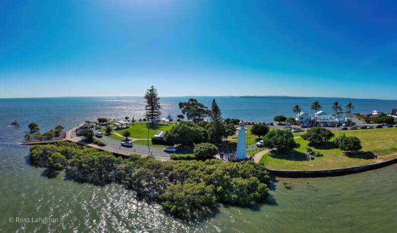
Cleveland Point marks one of the most picturesque locations on Brisbane's bayside.
The point extends into Moreton Bay and provides sweeping views across the islands and waterways.
The area is known for:
-
Cleveland Point Lighthouse
-
coastal walks
-
parklands
-
bay views
-
island scenery
From above, Cleveland Point creates a dramatic coastal composition with the shoreline extending into the bay.
Cleveland Point Lighthouse Photography
The lighthouse is one of the area's most recognisable landmarks.
Best photography conditions include:
Sunrise
Capturing:
-
morning reflections
-
soft coastal colours
-
calm water
Sunset
Capturing:
-
golden skies
-
silhouettes
-
distant island views
Storm Conditions
Summer weather can create dramatic skies above the bay, adding atmosphere and scale.
Southern Moreton Bay Islands
The waters surrounding Cleveland and Redland Bay provide access to several island environments including:
-
North Stradbroke Island (Minjerribah)
-
Russell Island
-
Macleay Island
-
Lamb Island
-
Karragarra Island
From above, these islands reveal:
-
mangrove systems
-
beaches
-
channels
-
reefs
-
tidal patterns
They form an important part of the wider Moreton Bay aerial landscape.
Best Photography Locations Across Moreton Bay & Redlands
Redcliffe Jetty
Best for:
-
sunrise
-
waterfront scenes
-
reflections
Woody Point
Best for:
-
sunset
-
bay panoramas
-
coastal lifestyle imagery
Wellington Point
Best for:
-
sandbars
-
islands
-
tidal photography
Cleveland Point
Best for:
-
lighthouse photography
-
sunrise
-
island views
Bramble Bay
Best for:
-
bridges
-
waterways
-
aerial patterns
Best Time for Aerial Photography
Sunrise
The best conditions often occur early morning when:
-
winds are lighter
-
water is calmer
-
reflections are stronger
-
colours are softer
Sunset
Ideal for:
-
western-facing locations
-
Woody Point
-
Cleveland Point
-
Bramble Bay
Low Tide
Particularly valuable for:
-
Wellington Point
-
sandbars
-
tidal patterns
-
shallow water photography
Storm Season
Summer storms create dramatic cloud formations and powerful coastal imagery.
Commercial Aerial Photography Licensing
Moreton Bay and Redlands aerial images are available for:
-
tourism marketing
-
regional promotion
-
editorial publications
-
websites
-
accommodation providers
-
commercial campaigns
-
corporate displays
These images showcase the relationship between Brisbane's urban coastline, islands and natural marine environments.
Additional FAQs
What areas are included in this Moreton Bay aerial photography guide?
This guide covers Bribie Island, Redcliffe Peninsula, Bramble Bay, Woody Point, Clontarf, Wellington Point, Cleveland Point and southern Moreton Bay.
Is Wellington Point good for photography?
Yes. Wellington Point is especially popular for aerial photography because of its tidal sandbars, island views and changing coastal patterns.
What is the best sunset location in Moreton Bay?
Woody Point, Cleveland Point and western-facing bayside locations provide excellent sunset opportunities.
What makes Moreton Bay unique for aerial photography?
The combination of islands, shallow waters, sandbanks, bridges and changing tides creates constantly evolving landscapes.
Can Moreton Bay images be licensed commercially?
Yes. Professional aerial images are available for tourism, editorial and commercial applications.
What is the best time to photograph Cleveland Point?
Early morning and late afternoon provide the most attractive light, particularly around the lighthouse and coastline.