
Gold Coast Destination Guide
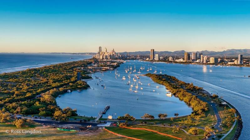
Surfers Paradise, Southport Broadwater, Gold Coast Seaway & Northern Gold Coast Waterways From Above
Discover the Gold Coast Through Aerial Photography
The Gold Coast is one of Australia's most spectacular coastal destinations, where golden beaches, waterways, islands and city landscapes combine to create a unique environment.
Known worldwide for its surf beaches and skyline, the Gold Coast also contains an extensive network of rivers, estuaries, islands and marine landscapes that reveal a different side of the region from above.
The aerial perspective showcases the connection between:
-
Pacific Ocean beaches
-
coastal waterways
-
river systems
-
islands and sandbanks
-
urban landscapes
-
wetlands and natural environments
Oz Straya Panoramas captures these landscapes through professional aerial photography, revealing the scale, patterns and beauty of Queensland's most recognisable coastal city.
This destination guide explores:
-
Surfers Paradise
-
Southport
-
Gold Coast Broadwater
-
Gold Coast Seaway
-
Main Beach and The Spit
-
Wavebreak Island
-
Coomera River
-
Northern Gold Coast waterways
The Gold Coast Coastal Landscape
The Gold Coast is shaped by the interaction between the Pacific Ocean, rivers and tidal waterways.
The region contains a diverse coastal environment including:
-
surf beaches
-
estuaries
-
marine channels
-
islands
-
wetlands
-
river mouths
-
coastal lagoons
From above, these landscapes reveal patterns created by:
-
tides
-
currents
-
rainfall
-
seasonal changes
-
shifting sand formations
This makes the Gold Coast one of Queensland's most dynamic aerial photography locations.
Surfers Paradise
Australia's Iconic Beach Skyline
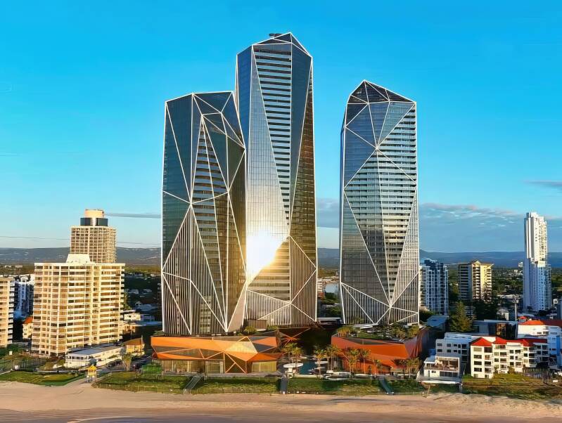
Surfers Paradise is the internationally recognised centre of the Gold Coast.
The destination combines a famous surf beach, high-rise skyline, entertainment precincts and a vibrant coastal atmosphere.
From above, Surfers Paradise reveals:
-
the sweeping Pacific Ocean coastline
-
golden beaches
-
high-rise buildings
-
coastal waterways
-
sunrise and sunset horizons
The contrast between the natural coastline and urban skyline creates some of the most recognisable aerial images in Queensland.
Photography Highlights
Surfers Paradise is ideal for:
-
sunrise beach photography
-
skyline panoramas
-
ocean patterns
-
golden-hour city landscapes
Southport
The Gateway to the Gold Coast Broadwater
Southport is the Gold Coast's central business and waterfront district, positioned beside the sheltered waters of the Broadwater.
The area combines:
-
waterfront parklands
-
marina landscapes
-
city development
-
marine environments
-
Broadwater views
From above, Southport showcases the relationship between the city and the water.
Aerial photography highlights:
-
waterfront precincts
-
boats and marinas
-
river channels
-
skyline views
-
coastal connections
Gold Coast Broadwater
Islands, Channels & Marine Landscapes
The Gold Coast Broadwater is one of the region's most distinctive waterways.
Located between the mainland and offshore island environments, the Broadwater creates a sheltered marine landscape containing:
-
tidal channels
-
sandbanks
-
islands
-
boating areas
-
wetlands
From above, the Broadwater reveals intricate patterns created by water movement and changing tides.
Aerial photography captures:
-
turquoise channels
-
island formations
-
boat trails
-
shoreline curves
-
reflections
The Broadwater is one of the strongest subjects within a Gold Coast aerial photography collection.
Gold Coast Seaway
Where the Broadwater Meets the Pacific Ocean
The Gold Coast Seaway is the dramatic connection between the Broadwater and the Pacific Ocean.
Located at the northern end of The Spit, the Seaway transformed the Nerang River entrance and created a more stable navigation channel between the ocean and inland waterways.
From above, the Seaway reveals:
-
ocean entrance channels
-
rock walls
-
tidal movement
-
sand bypass systems
-
boats entering the Broadwater
The contrast between open ocean and sheltered water creates exceptional aerial compositions.
Best Photography Conditions
Ideal conditions include:
-
sunrise over the ocean
-
incoming tides
-
calm water
-
dramatic coastal weather
Main Beach & The Spit
Coastal Barrier Between Ocean and Waterway
The Spit is one of the Gold Coast's most distinctive landscapes.
This narrow coastal strip separates:
-
the Pacific Ocean
-
Gold Coast Seaway
-
Broadwater
From above, it reveals:
-
long beaches
-
coastal dunes
-
waterways
-
marina areas
-
natural vegetation
The landscape demonstrates the connection between coastal processes and human development.
Wavebreak Island
Broadwater Island Landscape
Wavebreak Island is a defining feature of the northern Broadwater.
The island and surrounding shallow waters create a constantly changing aerial landscape.
Photography highlights:
-
sand formations
-
shallow turquoise waters
-
tidal channels
-
surrounding waterways
From above, Wavebreak Island demonstrates the natural patterns created by wind, waves and tides.
Coomera River
Northern Gold Coast Waterways
The Coomera River connects the Gold Coast Hinterland with the coastal waterways.
The river system includes:
-
estuaries
-
islands
-
marinas
-
wetlands
-
residential waterways
Aerial photography reveals the transition from inland catchments to coastal environments.
Best Gold Coast Photography Conditions
Sunrise
Best for:
-
ocean horizons
-
Broadwater reflections
-
soft golden light
Sunset
Ideal for:
-
river landscapes
-
skyline photography
-
glowing waterways
Low Tide
Creates:
-
visible sandbanks
-
channel patterns
-
shallow water colours
After Rainfall
Provides:
-
greener landscapes
-
dramatic skies
-
increased river flow
Explore More Queensland Landscapes
Continue exploring:
-
Tweed Coast NSW
-
Moreton Bay Islands
-
Brisbane River
-
SEQ Dams & Waterways
-
Gold Coast Hinterland
-
Scenic Rim Mountains
Experience the Gold Coast From Above
The Gold Coast is more than beaches and skyscrapers.
From the skyline of Surfers Paradise and the waterways of Southport Broadwater to the Seaway, Jacobs Well and Cabbage Tree Point, aerial photography reveals a coastline shaped by ocean, rivers, islands and tides.
Through professional aerial photography, the hidden patterns of the Gold Coast become visible — connecting city, coast and waterways into one extraordinary landscape.
Commercial Aerial Photography & Image Licensing
Gold Coast aerial images are suitable for:
-
tourism campaigns
-
accommodation marketing
-
real estate promotion
-
marine businesses
-
editorial publications
-
corporate displays
-
landscape artwork
Professional aerial photography provides a unique perspective of the Gold Coast's beaches, waterways and urban landscapes.
🌴 Gold Coast Aerial Photography Guide – 50 FAQs
🌅 General Overview
1. Where is the Gold Coast located?
The Gold Coast is in South East Queensland, Australia, south of Brisbane.
2. Why is the Gold Coast famous for aerial photography?
Because it combines beaches, skyline, canals, rivers, and hinterland mountains in one region.
3. What makes Gold Coast landscapes unique from above?
The contrast between ocean surf beaches and dense urban skyscrapers.
4. Is the Gold Coast good for drone photography?
Yes, it is one of Australia’s most diverse aerial photography locations.
5. What types of scenery can you capture?
Beaches, canals, islands, rainforests, mountains, and city skylines.
📸 Aerial Photography Appeal
6. What is the most iconic aerial view on the Gold Coast?
Surfers Paradise skyline from above the beach and river.
7. Why are canals popular for drone photography?
They create geometric patterns and reflective water compositions.
8. What makes beaches visually strong from above?
Clean lines of sand, surf, and ocean gradients.
9. Can you capture both city and nature in one shot?
Yes, the Gold Coast allows mixed urban and natural compositions.
10. What is the best aerial composition style?
Wide cinematic panoramas with coastline leading lines.
🌤️ Best Time for Photography
11. What is the best time to photograph the Gold Coast?
Sunrise and sunset for soft lighting and reflections.
12. Why is sunrise ideal?
Calm winds and clean beach conditions create sharp images.
13. Is sunset good for skyline photography?
Yes, it enhances warm tones on buildings and water.
14. Are cloudy days useful?
Yes, they reduce harsh glare and improve mood.
15. Does wind affect drone photography?
Yes, coastal winds can impact stability.
🚁 Drone Photography Tips
16. Are drones allowed on the Gold Coast?
Yes, but CASA regulations must be followed.
17. What altitude is best for Gold Coast drone shots?
Typically 60–120 metres depending on composition.
18. Can you fly over beaches?
Only if you maintain safe distance from people.
19. Should you use ND filters?
Yes, they help control reflections on water and glass buildings.
20. What camera settings work best?
Low ISO, RAW format, and balanced exposure.
🏙️ Key Locations
21. What are the best aerial photography locations on the Gold Coast?
Surfers Paradise, Broadbeach, Burleigh Heads, and The Spit.
22. Why is Surfers Paradise popular?
It has iconic high-rise buildings and beachfront skyline views.
23. What is The Spit known for?
Long shoreline perspectives and open coastal views.
24. Why is Burleigh Heads good for photography?
It combines headlands, surf breaks, and city views.
25. Are canals good for photography?
Yes, especially at sunrise for reflections.
🌿 Landscape & Environment
26. What types of environments exist on the Gold Coast?
Beaches, rivers, canals, rainforests, and mountains.
27. What is the Gold Coast hinterland?
A mountainous rainforest region behind the city.
28. Are there waterfalls near the Gold Coast?
Yes, especially in Springbrook and Lamington National Parks.
29. Why is water important in compositions?
It creates reflections and natural leading lines.
30. Are sandbars visible from the air?
Yes, especially at low tide in estuaries and beaches.
🌅 Lighting & Conditions
31. What weather is best for aerial photography?
Clear skies or light cloud with low wind.
32. Does humidity affect photography?
Yes, it can create haze over long distances.
33. Are sunsets reliable on the Gold Coast?
Yes, especially over ocean-facing beaches.
34. Is winter good for drone photography?
Yes, it offers clearer air and softer light.
35. Does rain improve photography?
Only when shooting reflections after storms.
📍 Access & Viewing
36. Is the Gold Coast easy to access for photographers?
Yes, it has excellent road and public access.
37. Are there public lookouts?
Yes, many coastal parks and headlands.
38. Is the area crowded?
Yes, especially during holidays and weekends.
39. Best time to avoid crowds?
Early mornings on weekdays.
40. Are there photography tours available?
Yes, including drone and landscape workshops.
📷 Commercial & Stock Photography
41. Are Gold Coast aerial images in demand?
Yes, especially for tourism and real estate marketing.
42. Can Gold Coast photos be sold commercially?
Yes, depending on licensing rights.
43. What industries use these images?
Tourism, advertising, real estate, and media.
44. Are skyline images valuable?
Yes, especially Surfers Paradise aerial views.
45. Why is Gold Coast stock photography valuable?
It combines lifestyle, tourism, and urban imagery.
🚁 Safety & Regulations
46. Are drones restricted in some Gold Coast areas?
Yes, especially near airports and crowded beaches.
47. What are CASA drone rules in Australia?
They regulate altitude, distance from people, and restricted airspace.
48. Can you fly near Surfers Paradise?
Yes, but you must avoid flying over crowds.
49. What is the biggest drone risk?
Flying over people or ignoring airport zones.
50. What is the most common mistake photographers make?
Ignoring wind conditions and crowd density during flights.
Links to Photography Collections
This aerial photography collection was captured by Brisbane-based aerial landscape photographer Ross Langdon, specialising in South East Queensland landscapes including mountains, coastlines, waterways and national parks