

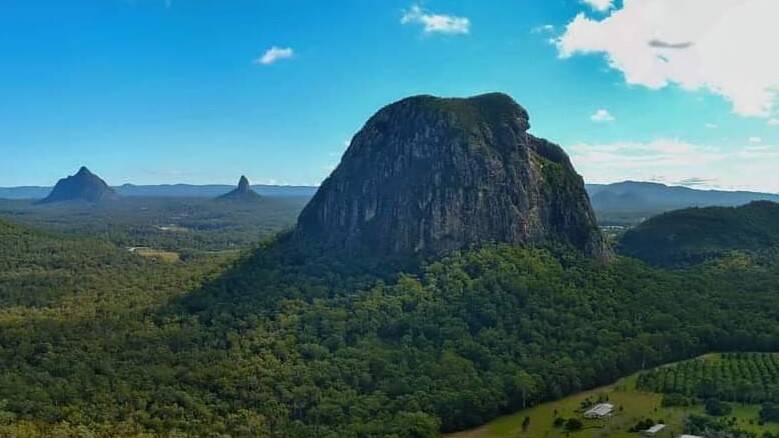
Mount Tibrogargan Queensland:
Climbing, Views & Photography
Mount Tibrogargan is one of the most recognisable peaks on Queensland's Sunshine Coast. Rising to 364 metres above sea level, it may not be a high mountain by Australian standards, but its dramatic rock faces, distinctive profile and spectacular position within the Glass House Mountains make it one of the region's most fascinating natural landmarks.
Located between Beerburrum and Glass House Mountains, Mount Tibrogargan is easily reached from the Sunshine Coast and is particularly rewarding for photographers, bushwalkers, rock climbers and anyone interested in the volcanic landscape of south-east Queensland.
But Tibrogargan is also a mountain that deserves respect. Its steep rock faces can be deceptive. The summit routes involve exposed rock, loose and unstable sections, steep slabs and near-vertical terrain. Queensland Parks and Wildlife Service specifically warns that serious injuries and deaths have occurred on the Glass House Mountains summit routes.
Where is Mount Tibrogargan?
Mount Tibrogargan is part of the Glass House Mountains National Park, approximately an hour north of Brisbane, depending on traffic and your starting point.
The main Tibrogargan trailhead is accessed via Marshs Road and Barrs Road, between the townships of Beerburrum and Glass House Mountains. From the trailhead, visitors can explore the Tibrogargan Circuit and the longer Trachyte Circuit.
The mountain sits among a remarkable collection of volcanic peaks, including Mount Beerwah, Mount Coonowrin, Mount Tibberoowuccum, Mount Ngungun and Mount Tunbubudla.
Although these mountains are relatively modest in elevation, they rise dramatically from the surrounding landscape. That contrast is one of the reasons the Glass House Mountains are so visually impressive.
Why is Mount Tibrogargan so attractive?
The first impression of Tibrogargan is its shape.
Viewed from the east, the mountain has a distinctive, almost human appearance, with the steep rock face forming a dramatic profile above the surrounding forests.
This makes Tibrogargan particularly attractive to photographers.
The mountain changes character throughout the day. Early morning and late afternoon light can emphasise the texture of the trachyte cliffs, while changing cloud, mist and shadows can completely alter its appearance.
For aerial photographers, the mountain is even more compelling. Its isolated volcanic form, surrounding forest and relationship with the neighbouring Glass House Mountains create a landscape that is difficult to appreciate fully from ground level.
A mountain with deep cultural significance
Mount Tibrogargan is more than a spectacular geological feature.
The Glass House Mountains are an important cultural landscape for Aboriginal Traditional Owners, and their spiritual significance is well recognised. Queensland Parks and Wildlife Service notes that Traditional Owners have expressed concerns about visitor impacts on the peaks, including erosion, vegetation damage and a lack of respect for cultural values.
The well-known Aboriginal story associated with the Glass House Mountains tells of Tibrogargan and the other mountains as a family. The story is an important part of the cultural identity associated with this landscape.
Visitors should therefore treat the mountain as more than a recreational climbing destination. Staying on designated tracks where required, avoiding unnecessary damage to vegetation and respecting the cultural significance of the mountains are all part of responsible visitation.
Walking around the base of Mount Tibrogargan
You don't need to climb the mountain to experience it.
The Tibrogargan Circuit provides one of the best ways to appreciate the mountain from ground level. Queensland Parks and Wildlife Service describes the circuit as a Grade 3 walk, with the trail passing through casuarina, eucalypt and melaleuca forest. The circuit also provides several opportunities to view the mountain from different angles.
The Sunshine Coast's trail information describes the circuit as approximately 4.6 kilometres, making it a much more accessible option than attempting the summit.
For photographers, this is an important distinction.
Some of the best photographs of Tibrogargan do not require climbing it at all.
The changing perspective from the surrounding walking tracks can reveal features of the mountain that aren't obvious when standing directly beneath its cliffs.
The Mount Tibrogargan summit
The summit is a very different proposition from walking around the base.
Queensland Parks and Wildlife Service classifies the Tibrogargan summit route as a serious climb requiring high fitness and rock-scrambling skills. The ascent is described as equivalent to climbing approximately 76 storeys, despite the mountain's relatively low elevation of 364 metres.
The official advice is particularly important because the mountain can look deceptively approachable from below.
It isn't a conventional walking track.
The summit route contains exposed, steep rock, loose stones and near-vertical sections. There are also areas where rockfall presents a significant hazard.
For anyone unfamiliar with exposed scrambling or climbing, the summit should not be treated as an ordinary bushwalk.
The eastern views from Mount Tibrogargan's summit
One of the great rewards of reaching the summit of Mount Tibrogargan is the opportunity to look away from the climbing route and across the landscape to the east.
From the elevated summit, the surrounding country opens out dramatically. The perspective changes completely from the views experienced at the base of the mountain, allowing photographers to capture the Glass House Mountains as a broader landscape rather than simply photographing Tibrogargan's imposing rock face.
Queensland Parks and Wildlife Service notes that the summit provides spectacular views of nearby Mount Coonowrin, Mount Beerwah and Mount Tibrogargan, while the surrounding Glass House Mountains landscape provides a remarkable backdrop for landscape photography.
Why the eastern aspect is valuable for photographers
The eastern outlook is particularly interesting because it gives the photographer a sense of scale and separation between the volcanic peaks and the much flatter country surrounding them.
From ground level, Tibrogargan dominates the view. From the summit, the perspective is reversed: the photographer can look across and see the neighbouring peaks rising from the surrounding landscape.
This creates several photographic opportunities:
-
Layered mountain compositions – overlapping volcanic peaks can create strong layers of foreground, middle distance and background.
-
Wide landscape images – the elevated viewpoint provides a much broader sense of the Glass House Mountains landscape.
-
Changing atmospheric conditions – haze, morning mist and cloud can add depth between the individual peaks.
-
Sunrise and early-morning photography – softer light can reveal the texture and contours of the surrounding mountains.
-
Telephoto compositions – a longer lens can isolate individual peaks and compress the distance between them.
-
Environmental images – including the rock and vegetation around the summit can place the surrounding landscape into context.
For photographers, this is an important advantage of the summit: you are no longer simply photographing Mount Tibrogargan—you are photographing from Mount Tibrogargan.
A different perspective of the Glass House Mountains
The elevated viewpoint also helps explain why the Glass House Mountains are such a remarkable landscape.
The individual peaks are remnants of volcanic activity that rise abruptly from relatively low surrounding country. From the summit of Tibrogargan, that relationship becomes much easier to appreciate.
The result is particularly effective for panoramic photography. Rather than isolating one mountain, a photographer can create an image showing several peaks within the same composition.
The Queensland Government also highlights the broader panoramic qualities of the Glass House Mountains landscape, with viewpoints in the surrounding area providing expansive views towards the mountains, Moreton Bay and the Sunshine Coast.
Photographing the summit safely
The photographic opportunities should never come at the expense of safety.
The summit route is a steep climb requiring high fitness and rock-scrambling ability, and Queensland Parks warns that the route includes near-vertical rock and high-risk rockfall areas.
Photographers should therefore remain on safe, stable ground and avoid moving onto exposed cliff edges or unstable rock simply to obtain a better composition.
A telephoto lens can often achieve a much stronger image than moving closer to an edge.
This is especially important at Tibrogargan, where recent emergency incidents have highlighted the risks associated with attempting to obtain photographs from exposed positions.
The best summit photograph is ultimately the one that allows you to bring the landscape home without taking unnecessary risks to capture it.
Climbing the West Face of Mount Tibrogargan
The western side is generally the less intimidating side of Tibrogargan and is associated with the established summit route.
That description, however, should not be confused with "easy."
The official Queensland Parks information warns that the summit route contains very loose and unstable rock during the initial section before reaching the designated high-risk rockfall area. The route then continues onto a near-vertical rock face.
The main dangers include:
Loose rock
Rock and rubble can move unexpectedly beneath hands or feet. A climber can also dislodge rocks onto people below.
Exposure
As the route steepens, the consequences of a slip become increasingly serious.
Slippery rock
Wet conditions substantially increase the danger. Queensland Parks specifically advises against climbing when rain is expected because wet rock can become dangerously slippery.
Heat and dehydration
The exposed rock can become extremely hot, particularly during Queensland's warmer months. Heat exhaustion can turn a difficult climb into an emergency.
Difficulty descending
A common mistake is to think that reaching the summit means the difficult part is finished. Descending steep rock can be more psychologically and physically demanding than climbing it.
Rockfall
This is one of the most significant objective hazards. Loose material can fall without warning, and climbers above can unintentionally dislodge rocks.
Queensland Parks advises climbers to warn others if rocks are accidentally dislodged and never to throw rocks from the summit.
The West Face and Chicken Rock
For visitors approaching Mount Tibrogargan from the western side, the character of the mountain changes dramatically as the summit route becomes steeper.
The western ascent is often described as the more accessible side of Tibrogargan, but accessible should not be confused with easy. It is a steep rock scramble rather than a conventional walking track, and the upper section requires confidence moving over exposed rock.
One of the most recognisable features of this route is Chicken Rock.
What is Chicken Rock?
Chicken Rock is the intimidating rock step on the western summit route where the ascent changes from a steep walk into genuine rock scrambling.
The name is informal and has a simple origin: it is the point where some people decide that they have had enough and "chicken out." The name has become well established among climbers and regular visitors to Tibrogargan. Climbing references describe it as the intimidating start of the more demanding section of the western route.
It is easy to understand why.
As you approach Chicken Rock, the previously manageable track becomes increasingly steep. The rock surface rises sharply and the route requires the use of hands as well as feet. From this point, the ascent feels much more like climbing than hiking.
For someone accustomed to bushwalking on formed trails, the transition can be surprising.
What does Chicken Rock look like?
Chicken Rock is not simply a single isolated boulder.
It is a steep section of the western rock face where the route rises abruptly through exposed rock. The climbing references describe a prominent V-shaped groove and a steep starting section, with an alternative line on sloping rock. Beyond this initial obstacle, the route continues as a scramble towards the summit.
The important thing for visitors is that the difficulty is immediately obvious when you reach it.
There is no conventional staircase, handrail or maintained walking surface at this point. The rock itself becomes the route.
This is also why Chicken Rock can create a psychological barrier. Looking upward, the remaining climb appears substantially steeper than the walking track below, while looking back down gives the visitor a very different appreciation of the exposure.
Why is Chicken Rock dangerous?
The danger is not necessarily the height of the rock step itself. It is the combination of steepness, exposure, smooth or worn rock, fatigue and the consequences of losing a foothold.
A slip in an exposed scrambling section can result in a significant fall.
This is not merely a theoretical concern. In October 2025, a visitor reportedly fell approximately seven metres at Chicken Rock and required assistance from technical rescue crews before being evacuated by helicopter.
A further rescue occurred in January 2026 after a young climber fell near Chicken Rock and required an aerial evacuation. The incident occurred during very hot conditions, with temperatures reaching approximately 37°C.
These incidents demonstrate why the western route should not be regarded as a harmless tourist walk simply because it is commonly climbed.
The real challenge is often coming back down
One of the less obvious dangers of Tibrogargan is the descent.
A section of rock that feels manageable when climbing upward can feel considerably different when facing downhill. Foot placements are harder to see, balance becomes more difficult and fatigue can affect judgement.
For this reason, reaching the summit does not mean the risk has finished.
You still have to come down.
Queensland Parks and Wildlife Service advises visitors that the summit route requires high fitness and rock-scrambling skills, and recommends allowing sufficient time to complete the climb during daylight. The park also warns of loose and unstable rock and a high-risk rockfall area on the approach to the steep upper section.
A good place to turn around
Chicken Rock can also serve an important purpose for inexperienced visitors: it provides a natural point to reassess whether continuing is appropriate.
If you reach Chicken Rock and realise that the exposure, steepness or rock scrambling is beyond your experience, turning around is a sensible decision.
There is no requirement to reach the summit to have experienced Mount Tibrogargan.
The circuit around the mountain provides excellent views of the peak from below, and for many visitors this is the safer and more enjoyable way to appreciate its enormous rock walls and distinctive profile.
Queensland Parks specifically recommends the Tibrogargan Circuit as a family-friendly walk around the base of the mountain, providing good views of Tibrogargan and the surrounding landscape.
Chicken Rock is therefore more than just a named feature on Mount Tibrogargan.
It is the point where the mountain makes its character very clear: this is no longer an ordinary bushwalk.
West Face versus East Face
The western side and eastern side of Mount Tibrogargan provide very different experiences.
The west face contains the recognised summit route and Chicken Rock, followed by increasingly steep scrambling terrain towards the summit.
The east face, by comparison, presents a much more dramatic vertical appearance and contains technical climbing terrain. Queensland Parks describes Tibrogargan generally as a challenging and potentially dangerous rock-face climbing site requiring a high level of expertise and equipment.
This distinction is important for visitors.
The west summit route may be the more familiar way to reach the summit, but it is still a serious scramble. The east face should be regarded as a technical climbing environment rather than an alternative tourist route.
The East Face: A Much More Serious Climbing Environment
The eastern face of Tibrogargan is perhaps the mountain's most dramatic side.
It is the face most commonly associated with the mountain's imposing, almost vertical appearance, and it contains technical climbing routes and challenging scrambling terrain.
This is where the mountain changes from a difficult summit scramble into a serious climbing environment.
The east face should not be approached as an alternative tourist route.
Queensland Parks and Wildlife Service describes Mount Tibrogargan EAST FACE as a challenging and potentially dangerous rock-face climbing site requiring a high level of expertise and equipment, warning that severe injury or death can result from climbing accidents.
There are numerous climbing lines and variations on the mountain, ranging from scrambling terrain to significantly more technical climbing.
The important point for visitors is that the existence of a route does not mean that route is suitable for the average hiker.
Why the East Face is dangerous
The steepness is the obvious hazard.
But steepness is only one part of the problem.
The east face combines:
-
steep and exposed rock
-
potential rockfall
-
difficult route-finding
-
limited margin for error
-
changing weather conditions
-
slippery surfaces when wet
-
fatigue
-
heat exposure
-
difficult retreat options
-
consequences of a fall that can be severe
Some climbing sections also require specialist climbing knowledge and equipment.
This is why a photograph or video showing somebody apparently climbing the face can give a misleading impression of its difficulty.
A person who is experienced on Tibrogargan may make a difficult section appear straightforward.
For somebody without equivalent experience, the same terrain can be extremely dangerous.
The danger of following an unknown route
One of the most important warnings from Queensland Parks concerns people leaving established summit routes.
Side tracks and informal lines can lead towards dead ends, steep cliffs or locations from which retreat becomes extremely difficult.
This is particularly relevant to Tibrogargan because the mountain contains numerous climbing lines and variations.
A route that looks obvious from below may become very different once a climber reaches the rock face.
Do not assume that because someone has climbed a particular line in a video, it is an appropriate route for you.
Recent rescues are a reminder of the real risks
The dangers of Tibrogargan aren't theoretical.
In January 2026, emergency services responded to a serious climbing incident involving a young woman who fell near the mountain's Chicken Rock section and required an aerial evacuation. The incident occurred during extreme heat, with temperatures reported at 37°C.
In June 2026, emergency services again issued warnings about dangerous behaviour around the mountain after a video showed a person climbing onto exposed rock near the summit for a photograph without safety equipment. The warning followed other recent rescue incidents at Tibrogargan.
These incidents and numerous others illustrate an important point:
Tibrogargan's low elevation does not make it a low-risk mountain.
Its proximity to Brisbane and the Sunshine Coast, relatively short approach and modest height can make it appear much less serious than it actually is.
Who should climb Mount Tibrogargan?
For the ordinary visitor, the safest and most rewarding experience may simply be to walk around the mountain and photograph it from the surrounding trails.
Queensland Parks states that people accessing the summit routes should be well-prepared climbers with a high level of fitness and rock-scrambling experience. The summit routes are specifically described as unsuitable for young children and inexperienced people who cannot climb unassisted.
Technical climbing on the east face requires an even higher level of expertise and appropriate equipment.
If you have never climbed exposed natural rock before, Tibrogargan is not the place to learn by trial and error.
The safer way to experience Tibrogargan
For most visitors, the best experience is to appreciate the mountain without attempting its most dangerous terrain.
Consider:
Walk the Tibrogargan Circuit
A much more accessible way to experience the mountain and surrounding forest.
Visit the Mountain View lookout
The walking tracks provide changing perspectives of Tibrogargan and the neighbouring peaks.
Explore the Trachyte Circuit
This longer circuit links Tibrogargan and Tibberoowuccum and provides broader views across the volcanic landscape.
Photograph the mountain from surrounding viewpoints
For landscape photographers, the surrounding country often provides better compositions than standing directly beneath the summit.
Visit the Glass House Mountains Visitor and Interpretive Centre
The centre at Rotary Settlers Park in Glass House Mountains provides information about the region and its natural and cultural significance.
Safety checklist for Mount Tibrogargan
Before visiting, check current Queensland Parks information and park alerts.
If undertaking the summit route, official guidance includes:
-
Check the weather before leaving.
-
Do not climb in wet conditions or when rain is likely.
-
Allow enough time to finish in daylight.
-
Carry sufficient water.
-
Stay with your climbing companions.
-
Never climb alone.
-
Be prepared for heat and strong winds.
-
Stay well away from cliff edges.
-
Do not throw or dislodge rocks.
-
Do not leave the established summit route.
-
Turn back if conditions deteriorate.
-
Make sure your experience and equipment are appropriate for the terrain.
Most importantly, know when not to climb.
There is no shame in turning around.
On a mountain such as Tibrogargan, turning back can be the most experienced decision you make.
Mount Tibrogargan: Small in Height, Huge in Character
At only 364 metres, Mount Tibrogargan doesn't qualify as a high mountain.
But height isn't what makes Tibrogargan special.
It is the combination of its dramatic volcanic geology, distinctive profile, cultural significance, surrounding forest and challenging rock faces that gives the mountain its character.
For photographers, it is one of the most recognisable subjects in the Glass House Mountains.
For walkers, the surrounding circuits offer an accessible way to experience the landscape.
For experienced climbers, its rock faces provide genuinely challenging terrain.
And for everyone else, Tibrogargan is a reminder that a mountain doesn't need to be thousands of metres high to demand respect.
Admire it. Photograph it. Walk around it. And if you intend to climb it, understand the mountain before you commit to the rock.
Conditions, access arrangements and safety information can change. Always check the latest Queensland Parks and Wildlife Service information and park alerts before visiting.
Mount Tibrogargan Photography
Mount Tibrogargan is one of the most distinctive landmarks in the Glass House Mountains, and its dramatic profile changes significantly depending on the light, weather and viewpoint. From the broad western face to the rugged eastern cliffs, the mountain offers a remarkable range of photographic perspectives.
At Oz Straya Panoramas, we have photographed Mount Tibrogargan extensively from the air and from surrounding locations, capturing the mountain as part of the wider Glass House Mountains landscape. Aerial photography reveals details that are easily missed from ground level—the steep rock faces, surrounding forests, nearby peaks and the way Tibrogargan dominates the landscape around it.
Our Mount Tibrogargan aerial photography is available as high-resolution landscape imagery, showcasing this iconic Queensland landmark in its broader natural setting.
Explore our Mount Tibrogargan photography collection to see the mountain from a different perspective and discover images available for display and print.
For photographers, artists, designers and anyone with an appreciation for the Glass House Mountains, these aerial views provide a unique perspective on one of Queensland's most recognisable volcanic peaks.

Mount Tibrogargan Aerial Photography
For those interested in seeing Mount Tibrogargan from a different perspective, aerial photography reveals the mountain's distinctive form in relation to the surrounding Glass House Mountains landscape.
At Oz Straya Panoramas, I have captured Mount Tibrogargan from the air, creating high-resolution landscape images that show its dramatic rock faces, surrounding forest and relationship with the neighbouring volcanic peaks.
Explore the Mount Tibrogargan Aerial Photography collection to view available images and learn more about licensing and print options.
Add comment
Comments