

Redland Bay & Southern Moreton Bay Islands Destination Guide | Islands, Coastal Headlands & Aerial Photography Queensland
Explore Redland Bay aerial photography featuring Moreton Bay views, islands, waterways and coastal landscapes.
Professional Queensland aerial images available for licensing.
Click on any photo below to open gallery
Digital images are available to purchase for $75 per image
-
 Jacobs Well Gallery A$75.00
 -
 Cabbage Tree Point Gallery A$75.00


Redland Bay Destination Guide
Southern Moreton Bay Islands, Coastal Landscapes & Aerial Photography Queensland
1. Introduction
Redland Bay is one of South East Queensland’s most visually distinctive coastal destinations, combining tranquil waterways, island landscapes, mangrove ecosystems, marine environments and scenic bayside communities.
Located south-east of Brisbane within the Redlands Coast region, Redland Bay provides a gateway to the Southern Moreton Bay Islands and some of Queensland’s most rewarding coastal aerial photography locations.
From above, the landscape reveals a unique relationship between mainland Australia and the islands scattered throughout southern Moreton Bay.
Aerial photography captures:
- Redland Bay shoreline
- Weinam Creek waterways
- Victoria Point coastline
- Coochiemudlo Island
- Peel Island views
- Russell, Lamb and Macleay Island landscapes
- Wellington Point tidal patterns
- Cleveland Point coastal scenery
The region is particularly suited to aerial photography because the coastline changes constantly with:
- tides
- sunlight
- weather
- marine activity
At low tide, aerial images reveal hidden patterns across the bay:
- sandbars
- tidal channels
- shallow-water formations
- mangrove systems
At sunrise and sunset, the region transforms into a landscape of reflections, silhouettes and warm coastal colours.
Redland Bay’s appeal comes from its balance between natural environments and coastal communities. Unlike highly urbanised waterfront areas, the region maintains a relaxed island and marine character.
Important destinations within the Redland Bay region include:
- Redland Bay township
- Weinam Creek
- Victoria Point
- Coochiemudlo Island
- Cleveland Point
- Wellington Point
- Southern Moreton Bay Islands
Redland Bay is especially valuable for aerial storytelling because it demonstrates the connection between:
- mainland communities
- island environments
- marine ecosystems
- recreational boating
- coastal conservation
The aerial perspective transforms familiar locations into broader landscape stories.
A photograph of Coochiemudlo Island becomes a story about island geography.
A photograph of Wellington Point becomes a story about tides and coastal processes.
A photograph of Redland Bay becomes a story about the relationship between Brisbane and Moreton Bay.
For commercial users, Redland Bay aerial imagery provides valuable visual assets for:
- tourism campaigns
- regional marketing
- marine businesses
- publications
- environmental projects
- accommodation providers
- corporate displays
- fine art prints
Redland Bay represents one of South East Queensland’s strongest opportunities for coastal aerial photography because it combines natural beauty, island landscapes and authentic bayside character.
2. History and Cultural Heritage of Redland Bay
The history of Redland Bay extends thousands of years before European settlement, with the region forming part of the traditional lands and waters of the Quandamooka people.
The islands, waterways and coastal environments of southern Moreton Bay provided important cultural, spiritual and practical connections.
Traditional uses of the area included:
- fishing
- gathering marine resources
- movement between islands and mainland
- cultural practices connected with waterways
The marine environment was central to life in the region.
European Settlement
European settlement expanded throughout the Redlands region during the nineteenth century.
The area developed through:
- farming
- fishing
- timber industries
- coastal transport
- small-scale settlement
Redland Bay became known for its agricultural history and later its role as a gateway to the islands of southern Moreton Bay.
Maritime Heritage
The region has always maintained a strong connection with boating.
Important marine locations include:
- Weinam Creek
- Redland Bay harbours
- Victoria Point
- island ferry connections
These locations continue to support:
- recreational boating
- island transport
- tourism
Redland City Council maintains marine facilities across locations including Redland Bay, Victoria Point, Wellington Point and Coochiemudlo Island.
Island Connections
Southern Moreton Bay Islands form an important part of the region’s identity.
These include:
- Coochiemudlo Island
- Russell Island
- Lamb Island
- Macleay Island
- Karragarra Island
Coochiemudlo Island is accessed from Victoria Point and is recognised for its beaches, island environment and coastal character.
Modern Redland Bay
Today Redland Bay combines:
- coastal lifestyle
- boating culture
- conservation areas
- island communities
- tourism
Aerial photography provides a valuable record of this changing relationship between people and the marine environment.
3. Why Visit Redland Bay?
Redland Bay offers a quieter coastal experience compared with many developed waterfront destinations.
Visitors are attracted by:
Island Experiences
The region provides access to unique island environments including Coochiemudlo Island and the Southern Moreton Bay Islands.
These destinations offer:
- beaches
- walking trails
- wildlife
- boating experiences
Coastal Photography
Redland Bay is one of the best locations near Brisbane for coastal aerial photography.
The region offers:
- island silhouettes
- tidal landscapes
- marina patterns
- sunrise reflections
- calm bay waters
Wildlife and Nature
The region supports important ecosystems including:
- mangroves
- wetlands
- marine habitats
- bird environments
Relaxed Bayside Communities
Locations such as:
- Victoria Point
- Wellington Point
- Cleveland Point
combine natural scenery with accessible coastal experiences.
4. Iconic Redland Bay Locations & Aerial Photography Opportunities
Redland Bay Township
Redland Bay provides the gateway between mainland Queensland and the Southern Moreton Bay Islands.
Aerial opportunities include:
- shoreline landscapes
- boats
- waterways
- island views
- marine patterns
The area is particularly attractive during sunrise when calm waters create reflections.
Weinam Creek
Weinam Creek is one of the region’s most important marine gateways.
Aerial photography captures:
- waterways
- vessels
- channels
- coastal infrastructure
The organised patterns of boats and channels create strong compositions.
Victoria Point
Victoria Point provides access to Coochiemudlo Island and offers excellent coastal photography opportunities.
Subjects include:
- beaches
- shallow waters
- island views
- ferry connections
The Victoria Point–Coochiemudlo Island connection is an important part of the Southern Moreton Bay experience.
Coochiemudlo Island
Coochiemudlo Island is one of the most visually appealing locations in southern Moreton Bay.
Aerial photography reveals:
- island shape
- beaches
- surrounding clear waters
- vegetation patterns
The island’s compact size and sheltered coastal environment make it ideal for aerial landscape photography.
Wellington Point
Although geographically connected with Brisbane bayside, Wellington Point is an important visual companion to the Redland Bay coastal story.
Aerial highlights include:
- King Island tidal pathway
- sandbars
- Moreton Bay views
- coastal vegetation
The location is especially powerful at low tide.
Cleveland Point
Cleveland Point provides:
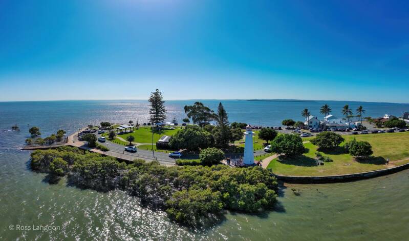
- historic lighthouse views
- rocky shoreline
- island perspectives
- sunrise opportunities
It is one of the strongest coastal landscape photography locations near Brisbane.
Jacobs Well
Southern Moreton Bay Gateway
Jacobs Well represents the northern gateway of the Gold Coast waterways.
Located near the Pimpama River and southern Moreton Bay, the area is surrounded by:
-
tidal creeks
-
wetlands
-
islands
-
fishing channels
-
coastal landscapes
From above, Jacobs Well reveals a complex network of waterways extending towards Moreton Bay.
Photography Highlights
Ideal subjects include:
-
river entrances
-
tidal patterns
-
boats and channels
-
wetland landscapes
-
sunrise reflections
Cabbage Tree Point
Logan River and Southern Moreton Bay Landscapes
Cabbage Tree Point provides a quieter coastal environment at the meeting point of river, wetlands and Moreton Bay.
The landscape features:
-
Logan River waterways
-
mangrove areas
-
tidal flats
-
islands
-
coastal vegetation
From above, Cabbage Tree Point reveals beautiful natural patterns created by:
-
winding channels
-
changing tides
-
river flow
-
coastal vegetation
This location adds important diversity to the Gold Coast aerial collection by showcasing natural waterways rather than urban coastline.
5. Best Redland Bay Aerial Photography Locations
Redland Bay and the surrounding Southern Moreton Bay region provide some of the strongest coastal aerial photography opportunities near Brisbane.
The region’s visual appeal comes from the interaction between:
- mainland coastline
- islands
- tidal waterways
- mangrove ecosystems
- marine infrastructure
- beaches
- boating activity
From above, Redland Bay becomes a connected coastal landscape rather than a series of individual locations.
The combination of changing tides, weather conditions and seasonal light creates almost unlimited photographic possibilities.
Redland Bay Shoreline & Waterfront
The Redland Bay coastline provides an excellent introduction to the Southern Moreton Bay landscape.
Aerial photography captures:
- curved shoreline patterns
- mangrove edges
- waterways
- boats
- island views
The calm waters of the bay are particularly effective during early morning when reflections create a mirror-like surface.
Important marine facilities around Redland Bay include Weinam Creek and Banana Street Harbour, which form important connections between mainland communities and island destinations.
Photography opportunities include:
- ferry movements
- boats leaving harbour
- marina patterns
- coastal transitions
Weinam Creek Aerial Photography
Weinam Creek is one of the most important marine gateways within Redland Bay.
From above, the area reveals the relationship between:
- mainland transport
- marine infrastructure
- island connections
- surrounding waterways
Aerial photography can capture:
- boat channels
- pontoons
- vessels
- shoreline vegetation
- Moreton Bay views
The organised patterns of boats and waterways create strong geometric compositions.
This location has excellent commercial potential for:
- marine businesses
- tourism operators
- regional marketing
- coastal development presentations
Victoria Point Aerial Photography
Victoria Point is one of the most important southern Moreton Bay locations because it provides access to Coochiemudlo Island and views across the bay.
Aerial photography opportunities include:
- Victoria Point coastline
- beaches
- ferry connections
- shallow-water patterns
- island landscapes
The area’s combination of mainland coastline and island views makes it visually distinctive. Victoria Point includes important marine facilities including jetties and boat access points connecting the community with the bay environment.
Best photographic conditions:
- sunrise over Moreton Bay
- low tide
- calm water
- winter mornings
Coochiemudlo Island Aerial Photography
Coochiemudlo Island is one of the most visually attractive locations in Southern Moreton Bay.
The compact island landscape provides classic Queensland coastal imagery.
From above, aerial photography reveals:
- sandy beaches
- turquoise shallow waters
- island vegetation
- coastal curves
- surrounding marine environment
The contrast between the island’s green vegetation and surrounding blue waters creates strong visual impact.
Coochiemudlo is particularly suited to:
- tourism campaigns
- accommodation marketing
- environmental storytelling
- fine art prints
The island’s ferry connection and harbour facilities make it an accessible example of the relationship between mainland and island communities.
Wellington Point Aerial Photography
Wellington Point is one of Brisbane’s most recognisable bayside photography locations and an important visual connection within the broader Redlands Coast region.
Its most famous feature is the tidal pathway connecting towards King Island.
From above, aerial photography captures:
- sandbar formations
- tidal channels
- shallow waters
- coastal vegetation
- Moreton Bay islands
The location changes dramatically depending on tide.
At low tide:
- sand patterns become visible
- the walking pathway appears clearly
- water channels create abstract designs
At high tide:
- the landscape transforms into open water
Wellington Point is particularly strong for sunrise photography.
Cleveland Point Aerial Photography
Cleveland Point provides one of the most iconic coastal compositions near Brisbane.
Key photographic features include:
- historic lighthouse
- rocky shoreline
- Moreton Bay views
- island horizons
- coastal vegetation
Aerial imagery reveals the shape of the point extending into the bay.
Best conditions include:
- early morning light
- calm water
- sunset conditions
Cleveland Point works particularly well for:
- tourism imagery
- regional branding
- wall art
Peel Island Aerial Photography
Peel Island provides an important natural and historical element within Moreton Bay.
Aerial photography captures:
- island shape
- beaches
- shallow waters
- marine patterns
The island demonstrates the scale and diversity of Moreton Bay’s protected environments.
It is particularly valuable for:
- environmental communication
- educational imagery
- conservation storytelling
Southern Moreton Bay Islands Aerial Photography
The wider island environment creates some of the most valuable aerial landscapes near Brisbane.
Important island locations include:
- Coochiemudlo Island
- Russell Island
- Macleay Island
- Lamb Island
- Karragarra Island
Aerial photography highlights:
- island geography
- ferry connections
- waterways
- coastal vegetation
- marine environments
The Southern Moreton Bay Islands provide a strong contrast to Brisbane’s urban coastline.
Redland Bay Tidal Photography
One of the greatest advantages of aerial photography in Redland Bay is the ability to capture tidal changes.
Low tide reveals:
- sandbanks
- mudflats
- channels
- water patterns
High tide creates:
- reflections
- deeper colours
- open-water landscapes
This makes Redland Bay suitable for abstract coastal photography.
6. Seasonal Photography Guide — Redland Bay & Southern Moreton Bay
Redland Bay changes throughout the year, with every season offering different aerial photography opportunities.
Summer — Tropical Colours & Dramatic Weather
Summer creates vibrant coastal imagery.
Conditions often include:
- bright blue water
- lush vegetation
- dramatic clouds
- storms over Moreton Bay
Storm formations can create powerful aerial compositions with:
- dark skies
- sunlight breaks
- reflections across waterways
Autumn — Clear Visibility & Calm Conditions
Autumn is often one of the best seasons for coastal aerial photography.
Advantages include:
- lower humidity
- clearer island views
- sharper horizon lines
- comfortable flying conditions
Ideal subjects:
- Coochiemudlo Island
- Wellington Point
- Cleveland Point
- Redland Bay shoreline
Winter — Sunrise, Calm Water & Atmospheric Conditions
Winter mornings often provide the most consistent conditions.
Benefits include:
- calm water
- golden sunrise light
- clear views across Moreton Bay
- soft coastal atmosphere
Winter is excellent for:
- commercial tourism imagery
- panoramic photography
- fine art landscapes
Spring — Wildlife & Coastal Renewal
Spring brings renewed activity throughout the region.
Photography opportunities include:
- bird activity
- greener coastal vegetation
- clearer waterways
The combination of fresh vegetation and coastal light creates attractive imagery.
7. Wildlife & Natural Landscapes of Redland Bay
Redland Bay supports important coastal ecosystems that connect mainland environments with Moreton Bay’s islands and marine habitats.
The region contains:
- mangroves
- wetlands
- tidal flats
- seagrass areas
- island ecosystems
Marine Wildlife
The waters around Southern Moreton Bay support:
- dolphins
- turtles
- fish species
- rays
- marine birds
Aerial photography provides a valuable way to show the scale of these habitats.
Birdlife
The coastal environment supports:
- pelicans
- sea eagles
- shorebirds
- migratory species
Tidal areas provide important feeding environments.
Mangrove and Wetland Systems
From above, mangroves create complex patterns along the coastline.
Aerial imagery helps demonstrate:
- coastal protection functions
- habitat connections
- environmental importance
8. Commercial Image Licensing — Redland Bay Aerial Photography
Professional aerial photography of Redland Bay, Southern Moreton Bay and the surrounding Redlands Coast provides valuable visual assets for organisations wanting to showcase one of Queensland’s most distinctive coastal environments.
The region’s combination of islands, beaches, marine landscapes, boating infrastructure and bayside communities creates imagery suitable for many commercial applications.
Tourism Campaigns & Regional Marketing
Redland Bay imagery is highly valuable for tourism organisations promoting:
- Redlands Coast
- Southern Moreton Bay Islands
- island experiences
- coastal recreation
- boating destinations
- bayside lifestyles
Aerial photography immediately communicates the scale and beauty of the region by showing the connection between mainland communities, islands and waterways.
Applications include:
- destination websites
- visitor guides
- tourism brochures
- advertising campaigns
- social media marketing
- promotional videos
Accommodation & Hospitality
Accommodation providers benefit from aerial imagery because it shows visitors the surrounding environment.
Suitable users include:
- island accommodation providers
- holiday rentals
- waterfront properties
- boutique stays
- tourism operators
Images can showcase:
- nearby beaches
- island locations
- waterfront access
- coastal surroundings
Aerial photography helps potential visitors understand the experience of staying within the Redland Bay region.
Marine & Boating Industry
Redland Bay has a strong maritime identity.
Aerial images are valuable for:
- marinas
- ferry operators
- boat businesses
- marine services
- boating publications
Photography can highlight:
- harbour layouts
- vessels
- waterways
- navigation channels
- coastal infrastructure
Environmental & Conservation Projects
Redland Bay’s marine ecosystems make aerial photography valuable for environmental communication.
Images can assist with:
- conservation campaigns
- coastal management projects
- educational resources
- research publications
Aerial perspectives clearly show:
- mangrove systems
- island environments
- tidal areas
- shoreline changes
Real Estate & Development Marketing
Coastal aerial photography provides valuable context for property and planning projects.
Images can demonstrate:
- proximity to waterways
- surrounding landscapes
- transport connections
- lifestyle features
Publications & Media
Redland Bay imagery is suitable for:
- travel magazines
- newspapers
- regional publications
- documentaries
- educational material
Authentic local photography creates stronger storytelling than generic stock images.
Fine Art Prints & Corporate Display
Redland Bay landscapes are highly suitable for premium wall art.
Popular subjects include:
- Coochiemudlo Island from above
- Wellington Point tidal patterns
- Cleveland Point lighthouse
- Southern Moreton Bay islands
- sunrise over Redland Bay waterways
These images can suit:
- offices
- hotels
- visitor centres
- corporate spaces
- private collections
Why Local Redland Bay Aerial Photography Has Value
A specialist local collection provides:
✓ authentic Queensland coastal imagery
✓ location-specific knowledge
✓ seasonal understanding
✓ original perspectives
✓ commercial licensing flexibility
Redland Bay represents an important part of South East Queensland’s coastal identity and provides strong opportunities for tourism, commercial and fine art photography.
9. Redland Bay Aerial Photography — FAQs
1. Where is Redland Bay located?
Redland Bay is located in South East Queensland within the Redlands Coast region, approximately 35 kilometres south-east of Brisbane.
The area sits on the southern shores of Moreton Bay and provides access to the Southern Moreton Bay Islands.
2. What is Redland Bay famous for?
Redland Bay is famous for:
- coastal landscapes
- island connections
- boating
- marine environments
- bayside lifestyle
- access to Southern Moreton Bay Islands
It is one of Queensland’s most important gateway locations for island travel.
3. Why is Redland Bay good for aerial photography?
Redland Bay is ideal for aerial photography because it combines:
- mainland coastline
- islands
- tidal patterns
- waterways
- marine infrastructure
- natural ecosystems
The landscape changes constantly with tides and weather.
4. What are the best aerial photography locations in Redland Bay?
Popular locations include:
- Redland Bay shoreline
- Weinam Creek
- Victoria Point
- Coochiemudlo Island
- Wellington Point
- Cleveland Point
- Peel Island
- Southern Moreton Bay Islands
5. Why photograph Redland Bay from above?
Aerial photography reveals features that are difficult to see from ground level, including:
- island shapes
- tidal channels
- sandbanks
- coastline patterns
- marine connections
6. What makes Redland Bay different from Brisbane coastal areas?
Redland Bay has a stronger island and marine identity.
Compared with Brisbane’s more urban coastline, Redland Bay offers:
- quieter waterways
- island landscapes
- natural coastal environments
- boating culture
7. What is Weinam Creek known for?
Weinam Creek is known as an important transport and marine hub connecting mainland Redland Bay with island communities.
It provides strong aerial photography opportunities due to its:
- waterways
- vessels
- harbour patterns
- coastal infrastructure
8. Why is Victoria Point popular for photography?
Victoria Point offers:
- coastal views
- island access
- beaches
- shallow-water landscapes
Its connection with Coochiemudlo Island creates unique aerial perspectives.
9. What makes Coochiemudlo Island special?
Coochiemudlo Island is known for:
- sandy beaches
- calm waters
- island vegetation
- peaceful coastal scenery
From above, the island creates a classic Queensland coastal composition.
10. Can Coochiemudlo Island be photographed from the air?
Yes. Aerial photography captures:
- island shape
- surrounding waters
- beaches
- vegetation patterns
- mainland connections
It is one of the strongest aerial photography subjects in southern Moreton Bay.
11. What is Wellington Point famous for?
Wellington Point is famous for its tidal connection to King Island and its views across Moreton Bay.
It is particularly popular for sunrise aerial photography.
12. Why is Cleveland Point good for aerial photography?
Cleveland Point provides:
- lighthouse views
- coastal landscapes
- island horizons
- sunrise opportunities
The peninsula shape creates strong aerial compositions.
13. What islands are near Redland Bay?
Southern Moreton Bay islands include:
- Coochiemudlo Island
- Russell Island
- Macleay Island
- Lamb Island
- Karragarra Island
14. What is the best time for Redland Bay aerial photography?
The best conditions often occur:
Winter mornings
- calm water
- golden light
Autumn
- clear visibility
Summer
- dramatic storms
Spring
- vibrant vegetation
15. Is sunrise or sunset better for Redland Bay photography?
Both provide excellent opportunities.
Sunrise often offers:
- calmer conditions
- softer light
- fewer people
Sunset provides:
- warm colours
- dramatic skies
- reflections
16. What wildlife can be seen around Redland Bay?
Redland Bay and Southern Moreton Bay support a diverse range of coastal and marine wildlife including:
- dolphins
- marine turtles
- fish species
- rays
- shorebirds
- seabirds
The combination of islands, wetlands and shallow marine environments creates important habitats throughout the region.
17. Are dolphins found near Redland Bay?
Yes. Dolphins are regularly found throughout Moreton Bay, including southern sections near Redland Bay and the surrounding islands.
The sheltered waters provide important feeding and breeding areas.
Aerial photography can help show the broader marine environment that supports these species.
18. What birds can be photographed around Redland Bay?
The region supports many coastal bird species including:
- pelicans
- sea eagles
- ospreys
- shorebirds
- migratory waders
Wetlands, mangroves and tidal flats provide important feeding areas.
19. Why are tides important for Redland Bay aerial photography?
Tides are one of the most important factors affecting coastal aerial photography.
At low tide, aerial images reveal:
- sandbanks
- tidal channels
- exposed shoreline
- shallow-water patterns
At high tide, the same areas become:
- reflective waterways
- open marine landscapes
- deeper blue coastal scenes
20. What weather creates the best Redland Bay aerial images?
Different weather conditions create different photographic opportunities.
Clear winter mornings:
- sharp island views
- calm water
- clean horizons
Summer storms:
- dramatic skies
- atmospheric conditions
- powerful contrasts
Cloudy conditions:
- soft coastal light
- reduced harsh shadows
Sunrise and sunset:
- warm colours
- reflections
- silhouettes
Commercial & Tourism FAQs
21. Can Redland Bay aerial images be used commercially?
Yes. Professional Redland Bay aerial imagery can be licensed for approved commercial purposes including:
- tourism marketing
- advertising
- websites
- publications
- corporate presentations
- environmental projects
22. Can tourism businesses use Redland Bay aerial photography?
Yes.
Tourism operators can use aerial imagery to promote:
- island experiences
- boating activities
- coastal accommodation
- marine tourism
- Redlands Coast destinations
Aerial images are especially effective because they immediately show location and landscape scale.
23. Can island accommodation providers use aerial images?
Yes.
Island and coastal accommodation businesses can use aerial photography to showcase:
- beaches
- waterways
- island surroundings
- ferry access
- nearby attractions
This helps visitors understand the complete destination experience.
24. Are Redland Bay images suitable for travel publications?
Yes.
Redland Bay aerial photography is suitable for:
- travel magazines
- tourism articles
- regional publications
- books
- online destination guides
Original local photography provides stronger storytelling and authenticity.
25. Can Redland Bay aerial footage be used in documentaries?
Yes.
Aerial footage is valuable for productions covering:
- Queensland coastal environments
- island communities
- marine conservation
- regional history
- tourism
The aerial perspective helps communicate the scale and connection of the landscape.
26. Why is aerial photography valuable for environmental projects?
Aerial imagery helps organisations document and explain:
- coastal ecosystems
- mangrove environments
- island habitats
- shoreline changes
- marine landscapes
The broad viewpoint allows viewers to understand environmental relationships.
27. What industries use Redland Bay aerial photography?
Industries that may use Redland Bay imagery include:
- tourism
- hospitality
- marine businesses
- real estate
- environmental organisations
- government
- education
- publishing
- corporate marketing
28. Why choose local Redland Bay aerial photography?
Local photography provides advantages including:
- authentic representation
- regional knowledge
- understanding of tides and seasons
- unique perspectives
- location accuracy
A local collection can capture conditions that generic stock photography often misses.
29. Are Redland Bay aerial images suitable for fine art prints?
Yes.
The region offers many subjects suitable for premium wall art:
- islands
- waterways
- tidal patterns
- sunrise reflections
- coastal landscapes
Aerial photography creates a different perspective from traditional coastal photography.
30. What are popular Redland Bay print subjects?
Popular subjects include:
- Coochiemudlo Island aerial views
- Southern Moreton Bay Islands
- Wellington Point tidal pathway
- Cleveland Point lighthouse
- Redland Bay waterways
- boats and marina patterns
31. Why photograph Redland Bay from above instead of ground level?
Ground photography captures individual scenes.
Aerial photography reveals:
- geographic relationships
- island connections
- coastline patterns
- marine environments
It tells the broader story of the region.
32. Where can professional Redland Bay aerial images be purchased?
Professional aerial images can be obtained through specialist Queensland aerial photography collections offering:
- commercial licensing
- editorial use
- tourism applications
- fine art print options
33. Why is Redland Bay one of Queensland’s best aerial photography destinations?
Redland Bay represents one of South East Queensland’s strongest coastal photography locations because it combines:
✓ Southern Moreton Bay Islands
✓ peaceful waterways
✓ beaches and coastline
✓ marine ecosystems
✓ boating culture
✓ tidal landscapes
✓ Brisbane coastal connections
From above, Redland Bay becomes a complete coastal story — showing how mainland communities, islands and marine environments connect together.
For tourism organisations, businesses, publications and collectors, Redland Bay provides imagery that captures the natural beauty and identity of Queensland’s bayside environment.