Redland Bay Destination Guide| Aerial Photography Queensland
Redland Bay & Southern Moreton Bay Destination Guide
Overview
The southern shores of Moreton Bay offer some of South East Queensland’s most captivating coastal landscapes, where sheltered waterways, tidal flats, island environments and scenic headlands create a unique aerial photography destination.
This region includes Redland Bay, Wellington Point, Cleveland Point, Victoria Point and Coochiemudlo Island, each offering a distinctive perspective of Moreton Bay’s natural beauty.
From above, the coastline reveals a spectacular mosaic of turquoise waterways, mangrove ecosystems, sandy foreshores, tidal channels, islands and coastal communities connected by the waters of Moreton Bay.
Oz Straya Panoramas captures these landscapes through professional aerial photography, showcasing the relationship between Brisbane’s bayside suburbs and the wider Moreton Bay marine environment.
Redland Bay Queensland
Redland Bay is a picturesque bayside community located south-east of Brisbane and is recognised as a gateway to the Southern Moreton Bay Islands.
The area features:
- Moreton Bay island views
- boating channels
- mangrove wetlands
- coastal parks
- peaceful waterfront landscapes
- sunrise and sunset photography locations
Aerial photography provides a unique perspective of the intricate coastline, revealing patterns created by tides, waterways and islands.
Wellington Point
Aerial Photography Highlights
Wellington Point is one of Brisbane’s most recognisable bayside locations, famous for its scenic peninsula extending into Moreton Bay.
From above, Wellington Point showcases:
- the iconic Wellington Point Reserve
- King Island sandbar
- Moreton Bay island views
- coastal walking areas
- tidal patterns surrounding the peninsula
The changing tides create dramatic aerial compositions, particularly during sunrise and sunset when reflections appear across the shallow waters.
Photography opportunities:
- sunrise over Moreton Bay
- King Island at low tide
- coastal landscapes looking towards Moreton Island
- aerial views of the peninsula and shoreline
Cleveland Point
Aerial Photography Highlights
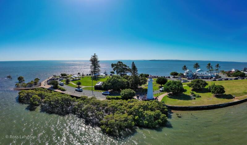
Cleveland Point is one of Redland City’s most photographed coastal locations, combining heritage, marine landscapes and panoramic bay views.
Aerial perspectives capture:
- Cleveland Point Lighthouse
- rocky shoreline
- Moreton Bay views
- mangrove and coastal ecosystems
- boats and marine activity
The point provides an excellent contrast between natural coastline and historic coastal architecture.
Photography opportunities:
- lighthouse surrounded by water
- sunset over Moreton Bay
- storm clouds across the bay
- coastal landscape compositions
Victoria Point
Aerial Photography Highlights
Victoria Point offers beautiful views across southern Moreton Bay, with coastal parks, beaches and access towards Coochiemudlo Island.
Aerial images reveal:
- Victoria Point Reserve
- Thompson Beach
- island waterways
- boating channels
- coastal vegetation
The shallow waters around Victoria Point create distinctive patterns visible only from above.
Coochiemudlo Island
Aerial Photography Highlights
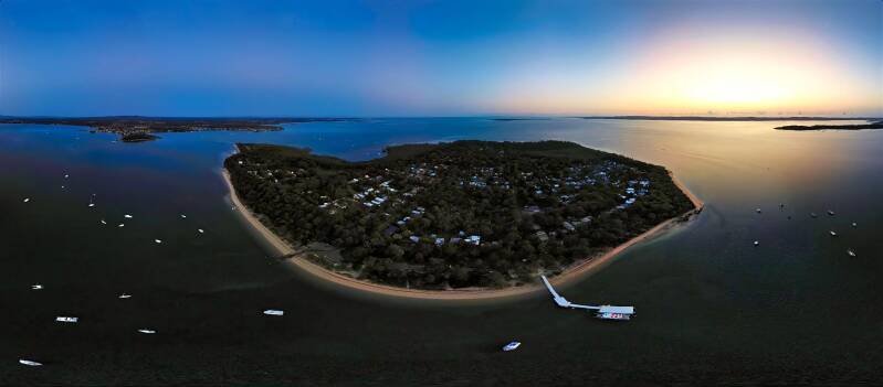
Coochiemudlo Island is a peaceful island destination located within southern Moreton Bay, known for its beaches, bushland and relaxed coastal atmosphere.
From above, the island displays:
- sandy beaches
- turquoise waters
- coastal vegetation
- boat channels
- connections with the mainland
Aerial photography highlights the contrast between the island’s natural landscape and the surrounding marine environment.
Photography opportunities:
- island coastline
- aerial beach patterns
- boats crossing Moreton Bay
- sunrise and sunset perspectives
Best Seasons for Photography
Winter (June–August)
- clearer skies
- lower humidity
- excellent visibility across Moreton Bay
- stronger sunrise colours
Spring
- dramatic cloud formations
- vibrant coastal vegetation
Summer storms
- powerful aerial compositions featuring:
- storm cells
- dramatic skies
- reflections across waterways
FAQ – Redland Bay & Southern Moreton Bay Aerial Photography
Where is Redland Bay located?
Redland Bay is located in Redland City, approximately 35 km south-east of Brisbane, Queensland.
What areas are included in this aerial photography collection?
The collection includes Redland Bay, Wellington Point, Cleveland Point, Victoria Point and Coochiemudlo Island.
Why is Southern Moreton Bay ideal for aerial photography?
The region combines islands, tidal waterways, beaches, headlands and coastal ecosystems that create unique patterns when viewed from above.
What is the best location for sunrise aerial photography?
Wellington Point, Cleveland Point and Redland Bay are particularly suited to sunrise photography due to their eastern-facing coastal views.
Can aerial images of these locations be licensed?
Yes. Professional aerial photographs can be licensed for commercial, editorial and fine art applications.
What makes Wellington Point unique from above?
The Wellington Point peninsula and King Island sandbar create distinctive shapes and tidal patterns that are especially visible from an aerial perspective.
Is Coochiemudlo Island part of Moreton Bay?
Yes. Coochiemudlo Island is located within southern Moreton Bay and is accessible from Victoria Point.
Are these images available for tourism and commercial use?
Yes. Licensing is available for tourism campaigns, publications, businesses and organisations requiring professional Queensland coastal imagery.
Commercial Applications
Southern Moreton Bay aerial photography is suitable for:
- tourism marketing
- visitor publications
- environmental reports
- coastal management projects
- corporate offices
- hotels and accommodation
- editorial publications
- advertising campaigns