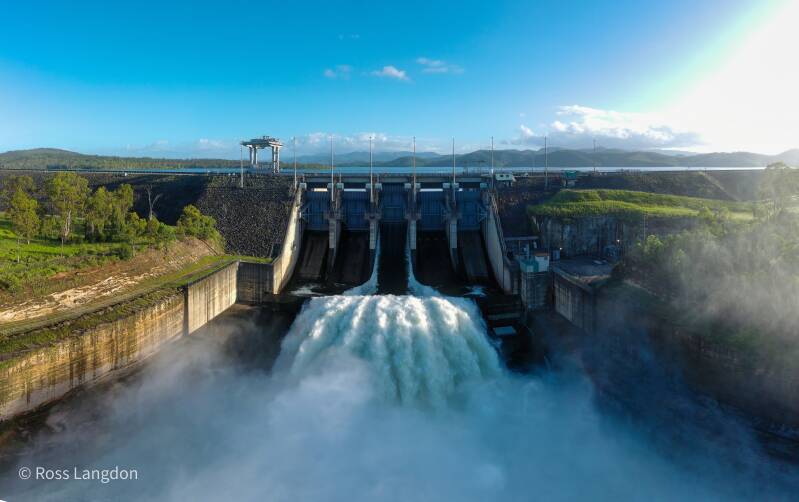
Dams & Lakes of South East Queensland Aerial Photography
Spectacular dams & lakes of South East Queensland.
Premium stock photography for tourism, editorial & commercial use.
Click on any photo below to open gallery
Digital images are available to purchase for $75 per image
Aerial Photography of Brisbane Reservoirs, Scenic Rim Lakes & Queensland Water Landscapes
Discover South East Queensland's Water Landscapes From Above
South East Queensland is home to a remarkable collection of reservoirs, lakes, rivers and waterways that shape the region's natural environment and communities.
From vast inland reservoirs surrounded by mountains to hidden forest lakes on Brisbane's western edge, these waterways reveal a constantly changing landscape influenced by rainfall, seasons and weather.
From above, SEQ's waterways showcase:
- expansive reservoirs
- winding river systems
- forest-covered catchments
- mountain reflections
- islands and peninsulas
- rural landscapes
- dramatic seasonal changes
Oz Straya Panoramas captures these landscapes through professional aerial photography, revealing the scale, patterns and beauty of Queensland's waterways.
This guide explores:
- Lake Wivenhoe
- Somerset Dam
- Hinze Dam
- North Pine Dam
- Lake Manchester
- Gold Creek Dam
- Enoggera Reservoir
- Lake Moogerah
- Lake Maroon
- Baroon Pocket Dam
- Borumba Dam
- Leslie Harrison Dam
- Brisbane River waterways
- Gold Coast waterways
Why South East Queensland Waterways Make Exceptional Aerial Photography
Water landscapes create some of the most visually dynamic aerial photography opportunities in Queensland.
Reservoirs constantly change with:
- rainfall
- water levels
- reflections
- cloud conditions
- seasonal vegetation
- sunlight
Aerial photography reveals details invisible from ground level:
- submerged valleys
- shoreline patterns
- river channels
- forest boundaries
- connections between mountains and waterways
These landscapes are ideal for:
- landscape artwork
- tourism promotion
- editorial use
- commercial licensing
- regional storytelling
Lake Wivenhoe
Queensland's Largest Inland Water Landscape
Lake Wivenhoe is one of South East Queensland's most significant reservoirs.
Located along the Brisbane River catchment, the lake provides water security and flood mitigation benefits for the region.
The landscape features:
- large open water areas
- forested hills
- winding bays
- rural surroundings
- Brisbane River connections
From above, Lake Wivenhoe reveals the enormous scale of the catchment and the relationship between water, farmland and surrounding mountain ranges.
Photography Highlights
Best conditions:
- sunrise reflections
- morning mist
- calm water
- dramatic summer skies
Somerset Dam & Lake Somerset
Mountain Valleys and Inland Waterways
Lake Somerset is one of Queensland's most scenic inland reservoirs.
Surrounded by hills, forests and rural landscapes, it provides outstanding aerial photography opportunities.
Key features include:
- winding shorelines
- sheltered bays
- mountain backdrops
- changing water patterns
The combination of water and surrounding countryside creates a strong visual connection between natural and agricultural landscapes.
Hinze Dam
Gold Coast Hinterland Water Landscape
Hinze Dam is one of the most scenic reservoirs in the Gold Coast Hinterland.
Surrounded by forested mountains, the reservoir demonstrates the close connection between water storage and the region's rainforest landscapes.
Aerial photography highlights:
- winding waterways
- forest-covered valleys
- mountain reflections
- shoreline patterns
Hinze Dam is particularly impressive when combined with nearby Gold Coast Hinterland landscapes.
North Pine Dam
Brisbane's Northern Reservoir Landscape
North Pine Dam, also known as Lake Samsonvale, provides an important water landscape north of Brisbane.
From above, the reservoir reveals:
- sheltered bays
- forested shorelines
- changing water levels
- surrounding bushland
The lake provides a contrast between Brisbane's urban environment and surrounding natural landscapes.
Brisbane Western Reservoirs
Lake Manchester, Gold Creek Dam & Enoggera Reservoir
Hidden Water Landscapes on Brisbane's Mountain Edge
Western Brisbane contains some of the city's most scenic and historic reservoirs.
Lake Manchester, Gold Creek Dam and Enoggera Reservoir sit among bushland, forested valleys and the foothills of the D'Aguilar Range.
These waterways provide a unique combination of:
- natural landscapes
- historic engineering
- forest catchments
- mountain scenery
From above, they reveal how Brisbane's water infrastructure follows the natural shape of the landscape.
Lake Manchester
A Quiet Forest Reservoir West of Brisbane
Lake Manchester is a peaceful reservoir surrounded by native bushland and forested hills.
Located approximately 25 kilometres west of Brisbane, the reservoir forms part of the SEQ water network and was originally constructed in 1916.
From above, Lake Manchester showcases:
- winding shoreline formations
- secluded bays
- forest-covered ridges
- narrow water channels
- untouched bushland
The contrast between the dark water and surrounding eucalyptus forest creates striking aerial compositions.
Best Photography Conditions
Lake Manchester is ideal during:
- early morning mist
- winter sunrise
- calm weather
- post-rainfall conditions
Gold Creek Dam
Brisbane's Historic Mountain Reservoir
Gold Creek Dam is one of Brisbane's most significant historic water landscapes.
Constructed in 1885, the dam was originally built to supplement Enoggera Dam. The two reservoirs are connected within Brisbane's western catchment system.
Surrounded by forest and steep valleys, Gold Creek Dam provides a unique aerial subject.
Photography highlights include:
- historic dam wall
- forest catchments
- reservoir patterns
- mountain scenery
The location is especially impressive after rainfall when the surrounding vegetation becomes vibrant green.
Enoggera Reservoir
Brisbane's Gateway to the D'Aguilar Range
Enoggera Reservoir is one of Brisbane's most recognisable inland water landscapes.
Built in 1866, it is one of Brisbane's oldest reservoirs and remains an important natural and recreational landscape near the western suburbs.
From above, Enoggera Reservoir reveals:
- broad water expanses
- forested shorelines
- sheltered coves
- mountain backdrops
The reservoir creates a natural transition between Brisbane's urban environment and the surrounding mountain ranges.
Photography Highlights
Best conditions:
- sunrise reflections
- winter mornings
- misty weather
- calm water
Lake Moogerah
Scenic Rim Mountains Reflected in Water
Lake Moogerah is one of Queensland's most photogenic mountain reservoirs.
Located within the Scenic Rim, the lake sits beneath dramatic mountain landscapes.
Aerial photography captures:
- mountain reflections
- islands
- curved shorelines
- rural landscapes
This location connects strongly with your Scenic Rim destination guide.
Lake Maroon
A Peaceful Scenic Rim Waterway
Lake Maroon combines:
- calm water
- mountain views
- forest edges
- rural landscapes
From above, the lake reveals beautiful patterns where water meets surrounding countryside.
Baroon Pocket Dam
Sunshine Coast Hinterland Lake Landscape
Located near Maleny and Montville, Baroon Pocket Dam combines rainforest, mountains and waterways.
Aerial photography highlights:
- rainforest-covered hills
- winding shoreline
- hinterland scenery
- mountain environments
Borumba Dam
Island Landscapes and Mountain Waterways
Borumba Dam near Imbil provides some of Queensland's most dramatic inland water scenery.
From above, the reservoir reveals:
- island formations
- forested shorelines
- winding channels
- mountain backdrops
Brisbane River Waterways
The Lifeline of South East Queensland
The Brisbane River connects many of the region's major landscapes.
From inland catchments through Brisbane City and towards Moreton Bay, the river creates diverse aerial photography opportunities.
Images capture:
- river bends
- bridges
- wetlands
- urban waterways
- natural corridors
Best Photography Conditions
Sunrise
Ideal for:
- reflections
- mist
- soft colours
- calm water
Sunset
Creates:
- warm tones
- mountain silhouettes
- dramatic shadows
After Rainfall
Produces:
- greener landscapes
- fuller waterways
- atmospheric conditions
Winter
Provides:
- clearer visibility
- crisp mountain views
SEQ Dams, Lakes & Waterways Aerial Photography Guide – 50 FAQs
🌄 General Overview
1. What are SEQ dams and lakes?
SEQ dams and lakes are water storage and recreation areas across South East Queensland managed as part of the region’s water grid.
2. Why are SEQ dams popular for aerial photography?
Because they combine large-scale water bodies, surrounding mountains, and open landscapes ideal for drone imagery.
3. What makes dams visually interesting from above?
Their geometric shapes, spillways, shorelines, and reflections create strong compositional elements.
4. Are SEQ dams natural or man-made?
They are man-made reservoirs built for water supply, flood control, and recreation.
5. What is the SEQ Water Grid?
A connected system of dams and water sources supplying South East Queensland.
📸 Aerial Photography Appeal
6. Why are dams good for drone photography?
They offer wide, open spaces with minimal visual clutter and strong water-land contrast.
7. What makes lakes attractive from the air?
Reflections, shoreline patterns, and surrounding terrain variations.
8. What is the most common aerial composition?
Wide panoramas showing water curves and surrounding hills.
9. Can you capture symmetry in dam photography?
Yes, many dams have curved or linear structures ideal for symmetry shots.
10. What is the best visual feature of SEQ waterways?
The contrast between deep blue water and green hinterland landscapes.
🌤️ Best Time for Photography
11. What is the best time to photograph SEQ dams?
Sunrise and sunset for soft lighting and reflective water surfaces.
12. Why is sunrise ideal?
Calm winds often produce mirror-like water reflections.
13. Is sunset good for dam photography?
Yes, it creates warm tones across water and hills.
14. Are cloudy days useful?
Yes, they reduce glare and enhance mood in aerial shots.
15. Does wind affect water photography?
Yes, wind reduces reflections and creates surface texture.
🚁 Drone Photography Tips
16. Are drones allowed at SEQ dams?
Yes, but CASA rules and site-specific restrictions apply.
17. What altitude is best for dam photography?
Typically 60–120 metres depending on composition.
18. Should you fly over water or land?
Both, but maintain safe distance from infrastructure and people.
19. What camera settings work best?
Low ISO, fast shutter for sharp detail, and RAW format.
20. Are ND filters useful?
Yes, they help manage reflections and exposure on bright water.
🏞️ Key SEQ Dams & Lakes
21. What are major SEQ dams?
Wivenhoe Dam, Somerset Dam, Hinze Dam, and North Pine Dam.
22. What is Lake Wivenhoe known for?
It is the largest reservoir in South East Queensland.
23. What is Somerset Dam known for?
Recreation, boating, and scenic mountain surroundings.
24. What is Hinze Dam known for?
Its proximity to the Gold Coast and scenic hinterland views.
25. What is North Pine Dam used for?
Water supply and recreation near Brisbane.
🌿 Landscape & Composition
26. What landscapes surround SEQ dams?
Mountains, farmland, forests, and open countryside.
27. Why is contrast important in dam photography?
It enhances depth between water and land elements.
28. Are shorelines important compositions?
Yes, they create natural leading lines.
29. Do dams have islands or features?
Some reservoirs include submerged trees or land formations.
30. What is a strong aerial composition style?
Wide cinematic panoramas with layered terrain.
🌅 Lighting & Conditions
31. What weather is best for dam photography?
Clear or lightly cloudy conditions with minimal wind.
32. Does fog improve dam photography?
Yes, it adds atmospheric depth and softness.
33. Are reflections better in still water?
Yes, calm conditions produce mirror-like reflections.
34. Does rain improve or reduce visibility?
Rain improves water levels but reduces flying opportunities.
35. Is midday good for aerial photography?
Only for bright, high-contrast landscape shots.
📍 Access & Locations
36. Can you access SEQ dam viewpoints easily?
Yes, many dams have public recreation areas and lookouts.
37. Are all dam areas open to the public?
No, some zones are restricted for safety and operations.
38. Are there walking tracks around dams?
Yes, many lakes have trails and picnic areas.
39. Are SEQ dams crowded?
Some are busy on weekends, especially in summer.
40. What is the best time to avoid crowds?
Early mornings on weekdays.
📷 Commercial & Stock Photography
41. Are SEQ dam images in demand?
Yes, especially for tourism, engineering, and environmental use.
42. Can dam photos be licensed commercially?
Yes, depending on location restrictions and permissions.
43. What industries use dam aerial images?
Water management, tourism, real estate, and media.
44. Are aerial lake photos popular in marketing?
Yes, they are widely used for lifestyle and travel branding.
45. Why are SEQ waterways valuable for stock photography?
They represent key infrastructure and scenic Australian landscapes.
🚁 Safety & Regulations
46. Are drones restricted at SEQ dams?
Yes, some areas have restricted airspace or operational limits.
47. What are CASA drone rules in Australia?
They regulate altitude, distance from people, and no-fly zones.
48. Can you fly near dam walls?
Often restricted due to safety and infrastructure protection.
49. What is the biggest drone risk at dams?
Wind gusts and restricted airspace violations.
50. What is the most common mistake photographers make?
Flying too close to infrastructure or ignoring site rules.
Explore More Queensland Landscapes
Continue exploring:
- Scenic Rim Mountains
- Brisbane City & Brisbane River
- Gold Coast Hinterland
- Lamington National Park
- Springbrook National Park
- Moreton Bay Coastal Landscapes
Experience South East Queensland's Waterways From Above
From Brisbane's historic western reservoirs to vast mountain lakes and scenic inland waterways, South East Queensland's water landscapes reveal the connection between nature, communities and the environment.
Through aerial photography, these waterways become more than reservoirs — they become a visual story of Queensland's landscapes from above.
Commercial Aerial Photography & Licensing
SEQ water landscape images are suitable for:
- tourism campaigns
- environmental projects
- editorial publications
- accommodation marketing
- corporate displays
- landscape artwork
Professional aerial photography provides a unique perspective of Queensland's waterways.
🌊 Dams & Lakes of South East Queensland – Destination Guide
Discover the vast waterways, scenic reservoirs, and recreational lakes that help sustain South East Queensland while providing spectacular opportunities for photography, boating, fishing, and outdoor adventure.
About the Dams & Lakes of South East Queensland
South East Queensland is home to a network of major dams and reservoirs that supply drinking water, support flood mitigation, generate recreation opportunities, and create some of the region's most impressive inland landscapes.
From the expansive waters of Lake Wivenhoe to the forested shores of Hinze Dam in the Gold Coast hinterland, these lakes have become popular destinations for photographers, anglers, kayakers, hikers, and nature enthusiasts. Many are surrounded by national parks, bushland reserves, and wildlife habitats that offer panoramic aerial views and breathtaking scenery.
Local History
Indigenous Heritage
For thousands of years, the rivers and valleys that now contain many of South East Queensland's dams were important cultural landscapes for Aboriginal peoples. These waterways provided food resources, travel routes, gathering places, and spiritual connections that remain significant today.
Building Water Security
Rapid population growth and periodic droughts led to the construction of major water storages throughout the twentieth century.
Among the most significant projects was Wivenhoe Dam, completed in 1984 on the Brisbane River. It was designed to provide both water security and flood mitigation for Brisbane and surrounding communities. Today it remains the largest water storage in South East Queensland.
Hinze Dam on the Nerang River was developed to support the growing Gold Coast region and has undergone multiple upgrades to increase water storage capacity and improve flood mitigation capabilities.
Modern Importance
Today, the region's dams form part of an interconnected water network managed across South East Queensland. They continue to provide drinking water while supporting recreation, tourism, wildlife conservation, and outdoor activities.
Popular Lakes & Reservoirs
Lake Wivenhoe
South East Queensland's largest lake and primary water storage. Popular for:
- Boating
- Fishing
- Kayaking
- Mountain biking
- Horse riding
- Picnicking
- Scenic photography
The lake contains multiple recreation areas and offers extensive shoreline access.
Hinze Dam & Advancetown Lake
Located in the Gold Coast hinterland, Hinze Dam is surrounded by forested hills and walking trails. Visitors enjoy:
- Lakeside parks
- Cycling routes
- Walking tracks
- Birdwatching
- Scenic lookouts
- Photography opportunities
Other Notable Water Storages
South East Queensland also features numerous other reservoirs including:
- Somerset Dam
- Baroon Pocket Dam
- Borumba Dam
- Moogerah Dam
- North Pine Dam
Together these water bodies contribute to the region's water security and recreational opportunities.
Visitor Information
Best Time to Visit
Autumn & Winter (April–August)
- Comfortable temperatures
- Lower humidity
- Clearer skies
- Excellent aerial photography conditions
After Rainfall
- Higher water levels
- Lush surrounding landscapes
- Dramatic reflections and scenery
Popular Activities
✔ Scenic photography
✔ Aerial photography
✔ Fishing
✔ Kayaking and canoeing
✔ Boating
✔ Walking and cycling
✔ Birdwatching
✔ Picnics and family outings
Many lakes provide dedicated recreation areas, picnic facilities, and public access points.
Photography Tips
- Early morning provides calm water and reflections.
- Sunset creates dramatic colours across reservoirs.
- Aerial photography showcases shoreline patterns and surrounding landscapes.
- Winter often offers the clearest visibility.
Image Licensing Information
Standard Editorial Licence
Suitable for:
- News publications
- Educational materials
- Travel articles
- Blogs
- Documentary projects
Commercial Licence
Suitable for:
- Tourism campaigns
- Government publications
- Corporate marketing
- Advertising
- Websites and brochures
- Environmental and infrastructure reports
Fine Art & Display Licence
Perfect for:
- Corporate offices
- Visitor centres
- Hotels and resorts
- Public buildings
- Residential interiors
Licensing Restrictions
Unless specifically authorised:
- Images may not be resold as standalone digital files.
- Redistribution through stock agencies is prohibited.
- Images cannot be used in unlawful or misleading contexts.
- Additional permissions may be required for specialised commercial applications.
Please refer to the licence agreement supplied with your purchase.
Why These Images Are Popular
Aerial photography of South East Queensland's dams and lakes offers a unique perspective rarely seen from the ground. The combination of water, forests, mountains, and engineered infrastructure creates compelling imagery suitable for:
- Environmental publications
- Tourism promotion
- Infrastructure projects
- Educational resources
- Corporate displays
- Fine art prints
These photographs highlight the importance of water management while showcasing the natural beauty of Queensland's inland landscapes.