Scenic Rim Aerial Photography Guide – The Best Drone Views of Queensland's Mountain Landscapes
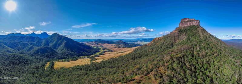
Drone photography of the Scenic Rim — Mount Mitchell, Mount Barney & Queen Mary Falls from above. License aerial images or shop fine-art prints.
Click on any photo below to open gallery
Digital images are available to purchase for $75 per image
Scenic Rim Destination Guide | Ancient Mountains, Rainforests, Valleys & Aerial Photography Queensland
1. Introduction
The Scenic Rim is one of South East Queensland’s most spectacular natural landscapes, where ancient mountains, World Heritage rainforests, fertile valleys and rural communities combine to create a destination of extraordinary beauty.
Located between Brisbane, the Gold Coast and the Queensland–New South Wales border, the Scenic Rim offers a dramatic contrast to the surrounding urban centres. The region is defined by a spectacular chain of mountain ranges forming a natural amphitheatre around valleys, forests, lakes and farmland. From the air, this landscape reveals a remarkable connection between geological history, natural ecosystems and human settlement.
Aerial photography provides a unique perspective of the Scenic Rim, showcasing the scale and diversity of this extraordinary region. From above, isolated volcanic peaks rise dramatically from surrounding valleys, rainforest-covered ranges extend across the horizon, and waterways such as Lake Moogerah reflect the mountains that surround them.
The Scenic Rim contains some of Queensland’s most recognisable landscapes, including Mount Barney, Mount Maroon, Mount Lindesay, Mount Tamborine, Main Range National Park, Lamington National Park and Moogerah Peaks National Park. Each location offers its own character, from rugged wilderness peaks and ancient rainforests to peaceful rural landscapes and scenic waterways.
The region’s visual appeal changes constantly with the seasons. Winter mornings often create atmospheric scenes as mist settles across valleys, while summer storms produce dramatic skies above mountain ridges. Autumn brings clear visibility and golden light, while spring transforms the landscape with fresh vegetation and vibrant colours.
Beyond its natural beauty, the Scenic Rim is a place of deep cultural significance. The mountains, rivers and forests hold thousands of years of connection for Traditional Custodians, including the Mununjali, Ugarapul and Yugambeh peoples. These landscapes are not only significant for their beauty but also for their cultural stories, traditions and ongoing connection to Country.
This aerial photography collection captures the diverse character of the Scenic Rim, from its ancient volcanic formations and rainforest environments to its rural communities and iconic mountain scenery. Through professional aerial imagery, the region’s scale, beauty and unique identity can be appreciated from a perspective impossible to experience from the ground.
2. History and Cultural Heritage of the Scenic Rim
The Scenic Rim has a rich history shaped by ancient geological forces, thousands of years of Indigenous connection and generations of rural settlement.
For Traditional Custodians, including the Mununjali, Ugarapul and Yugambeh peoples, the Scenic Rim is a living cultural landscape. The mountains, waterways, forests and valleys hold deep spiritual and cultural meaning, with stories, knowledge and traditions passed through generations.
The region’s mountains are central to many cultural stories and continue to represent important connections between people, Country and ancestors. Visitors are encouraged to recognise that these landscapes are more than scenic locations; they are places of ongoing cultural significance.
European exploration of the region began in the nineteenth century as explorers travelled through South East Queensland’s rugged mountain country. The dramatic peaks, fertile valleys and extensive forests attracted increasing interest as settlement expanded.
The volcanic soils of the Scenic Rim proved highly productive, supporting agriculture that remains an important part of the region today. Industries developed around:
- dairy farming
- cattle grazing
- fruit production
- vegetable farming
- vineyards
- local food production
Towns including Boonah, Beaudesert, Canungra, Kalbar and Tamborine Mountain developed as important regional centres, each reflecting the agricultural heritage and changing identity of the region.
Conservation has also played a major role in protecting the Scenic Rim’s natural heritage. National parks including Lamington, Main Range, Mount Barney and Moogerah Peaks protect significant ecosystems, including areas of ancient rainforest that form part of the Gondwana Rainforests of Australia World Heritage Area.
These protected landscapes preserve some of Australia’s most important biodiversity, including rare plants, native wildlife and unique mountain environments.
Today, the Scenic Rim represents a balance between conservation, agriculture, tourism and community life. Visitors can experience ancient landscapes while exploring local produce, heritage towns, walking trails, national parks and scenic viewpoints.
From above, the history of the region becomes visible through the patterns of the landscape. Mountain ranges stand beside farmland, roads follow natural valleys, waterways shape the countryside and communities exist alongside some of Queensland’s most remarkable natural environments.
The Scenic Rim’s history is therefore a story of connection — between ancient geology, Traditional Custodians, rural communities and the continuing protection of one of Queensland’s most important landscapes.
3. Why Visit the Scenic Rim
The Scenic Rim is one of Queensland’s premier nature destinations, offering a rare combination of dramatic mountain scenery, ancient rainforests, rural landscapes and authentic regional experiences.
Located within easy reach of Brisbane and the Gold Coast, the region provides visitors with the opportunity to experience some of South East Queensland’s most spectacular environments without travelling far from major cities.
Visitors are drawn to the Scenic Rim for:
- spectacular mountain views
- rainforest walks
- waterfalls
- scenic drives
- wildlife encounters
- local food and wine experiences
- photography opportunities
- peaceful rural landscapes
The region’s mountains create some of the most impressive scenery in Queensland. Mount Barney, Mount Maroon, Mount Lindesay, Mount Mitchell and the Main Range provide dramatic backdrops that dominate the surrounding countryside.
For photographers, the Scenic Rim offers exceptional opportunities throughout the year. The landscape changes dramatically depending on weather, season and light. Winter mornings can produce fog-filled valleys and crystal-clear mountain views, while summer storms create powerful images of mountains beneath dramatic skies.
The region is also recognised for its unique combination of nature and agriculture. The fertile valleys surrounding Boonah, Beaudesert and Kalbar showcase productive farmland framed by ancient mountain ranges. This relationship between rural landscapes and wilderness areas creates a visual identity that is uniquely Queensland.
Popular destinations include:
- Mount Barney National Park
- Lamington National Park
- Main Range National Park
- Moogerah Peaks National Park
- Lake Moogerah
- Tamborine Mountain
- Fassifern Valley
Aerial photography provides one of the best ways to appreciate the true scale of the Scenic Rim. From above, visitors can see how individual mountains connect with forests, valleys, lakes and rural communities to form one of Australia’s most distinctive landscapes.
For tourism operators, publications and businesses, Scenic Rim aerial imagery provides a powerful way to showcase the natural beauty, adventure opportunities and regional character of this remarkable Queensland destination.
The Scenic Rim is more than a collection of mountains — it is a landscape where ancient geology, living culture, biodiversity and rural heritage combine to create one of South East Queensland’s most inspiring destinations.
4. Geological Story of the Scenic Rim
The Scenic Rim is one of Australia’s most remarkable geological landscapes, shaped by ancient volcanic activity, erosion and millions of years of natural processes. The region’s dramatic mountains, escarpments, valleys and waterways tell the story of a landscape that has continually evolved over geological time.
Approximately 25–30 million years ago, intense volcanic activity transformed South East Queensland. Massive volcanic eruptions created large shield volcanoes and lava flows across the region. Over millions of years, erosion removed softer surrounding materials, leaving behind the more resistant volcanic formations that define the Scenic Rim today.
The result is a spectacular landscape of isolated peaks, mountain ranges and elevated plateaus surrounded by fertile valleys.
The Scenic Rim forms part of the broader volcanic landscapes of South East Queensland and northern New South Wales. Its mountain systems include the remnants of ancient volcanic structures, including:
- Mount Barney
- Mount Maroon
- Mount Lindesay
- Main Range
- Tamborine Mountain
- Moogerah Peaks
These formations demonstrate the powerful geological forces that shaped the region.
Mount Barney and Mount Maroon are particularly significant examples of volcanic landscapes. Their rugged granite formations, steep ridges and dramatic profiles reflect the slow cooling and erosion of ancient volcanic materials.
The elevated plateaus of Tamborine Mountain and Lamington National Park represent remnants of ancient volcanic landscapes that have been deeply weathered over time. These areas now support some of Australia’s most important rainforest ecosystems.
The geological history of the Scenic Rim has also influenced its soils, waterways and biodiversity. Volcanic soils created fertile conditions that support agriculture throughout the region, particularly around the Fassifern Valley, Boonah and Beaudesert areas.
The mountains influence local climate by creating elevated environments with increased rainfall and cooler conditions. This has allowed ancient rainforest communities to survive, including ecosystems associated with the Gondwana Rainforests of Australia World Heritage Area.
From an aerial perspective, the geological story becomes particularly clear. The relationship between mountains, valleys and waterways reveals the forces that shaped the landscape.
Aerial photography captures:
- ancient volcanic peaks rising above valleys
- erosion patterns across mountain ranges
- rainforest-covered ridges
- agricultural landscapes shaped by fertile volcanic soils
- waterways following natural geological formations
The Scenic Rim’s geology is therefore not only a scientific story but also a visual one. The dramatic landscapes that attract visitors today are the result of millions of years of geological evolution.
For photographers, the region provides an opportunity to document one of Queensland’s most extraordinary natural environments. Every mountain, valley and ridge represents a chapter in the geological history of South East Queensland.
5. Iconic Mountains, National Parks and Scenic Locations
Mount Barney National Park
Mount Barney National Park is one of the most iconic wilderness areas within the Scenic Rim and contains some of Queensland’s most dramatic mountain landscapes.
Established to protect the region’s unique geology, forests and wildlife, the park is characterised by rugged peaks, granite landscapes, rainforest valleys and remote wilderness.
The park forms part of the Gondwana Rainforests of Australia World Heritage Area and provides habitat for many native species.
From above, Mount Barney National Park reveals a spectacular landscape of:
- rugged mountain ridges
- forest-covered valleys
- granite formations
- winding waterways
- surrounding rural landscapes
The aerial perspective highlights the isolation and scale of this remarkable wilderness environment.
Mount Barney
Mount Barney is one of Queensland’s most recognisable mountains and a defining symbol of the Scenic Rim.
The mountain features two prominent peaks surrounded by steep ridges and dramatic terrain. Its distinctive shape dominates the surrounding landscape and provides one of the strongest visual representations of the region.
Mount Barney has significant cultural importance and remains an important landscape feature for Traditional Custodians.
Aerial photography opportunities include:
- sunrise over mountain ridges
- morning fog surrounding valleys
- dramatic storm clouds
- golden afternoon light
- wide views showing surrounding landscapes
From above, Mount Barney demonstrates the true scale of the Scenic Rim, showing how the mountain rises dramatically above forests and agricultural valleys.
Mount Maroon
Mount Maroon is one of the most visually striking peaks in the Scenic Rim.
Located near Mount Barney, the mountain features steep rocky cliffs, forest-covered slopes and dramatic ridgelines.
The rugged volcanic landscape creates some of the strongest aerial photography opportunities in Queensland.
Aerial images can capture:
- exposed rock formations
- mountain shadows
- surrounding wilderness
- changing cloud patterns
- distant Scenic Rim ranges
Mount Maroon is particularly impressive during early morning and late afternoon when low-angle sunlight highlights the mountain’s textures and dramatic shape.
The combination of rugged geology and surrounding natural landscapes makes Mount Maroon an important subject for landscape photographers.
Mount Lindesay
Mount Lindesay is one of the most distinctive volcanic formations in the Scenic Rim and is located near the Queensland–New South Wales border.
The mountain rises prominently above surrounding rural landscapes and has long been recognised as a major landmark in the region.
Its isolated position creates a powerful sense of scale, particularly when viewed from above.
Aerial photography opportunities include:
- the mountain surrounded by farmland
- border region landscapes
- sunrise silhouettes
- dramatic cloud formations
- wide regional views
Mount Lindesay demonstrates the relationship between ancient geological formations and modern rural landscapes.
Main Range National Park
Main Range National Park protects one of the most important mountain environments within the Scenic Rim.
The park contains dramatic peaks, rainforest ecosystems, escarpments and important wildlife habitats.
The landscape includes several significant locations ideal for aerial photography.
Mount Mitchell
Mount Mitchell is one of the prominent peaks within Main Range National Park.
The mountain features steep forested slopes, ridges and elevated viewpoints overlooking the surrounding countryside.
Aerial photography captures:
- mountain ridgelines
- rainforest landscapes
- valleys below
- changing weather conditions
Mount Mitchell represents the rugged wilderness character of the Scenic Rim.
Mount Cordeaux
Mount Cordeaux is one of the most recognisable peaks within the Main Range landscape.
Its elevated position provides spectacular views across the Fassifern Valley and surrounding mountain country.
Aerial photography highlights:
- dramatic escarpments
- rainforest-covered slopes
- mountain ridges
- surrounding agricultural landscapes
The mountain provides a strong connection between wilderness and rural Queensland.
Bare Rock
Bare Rock is an impressive elevated viewpoint within the Main Range region.
The exposed summit provides expansive views across the surrounding landscape.
From above, Bare Rock reveals:
- rocky ridges
- forest patterns
- deep valleys
- surrounding mountain ranges
The location is particularly effective for sunrise and sunset photography.
Spicers Gap
Spicers Gap is a historic mountain pass within the Main Range landscape.
The location has played an important role in connecting inland and coastal regions and remains a significant natural and cultural landmark.
Aerial photography captures:
- mountain passes
- winding roads
- forested ranges
- surrounding valleys
Spicers Gap demonstrates how the region’s geography has influenced human movement and settlement.
Moogerah Peaks National Park
Moogerah Peaks National Park is one of the Scenic Rim’s most visually impressive mountain landscapes, featuring dramatic volcanic peaks, forested ridges and panoramic views across the surrounding countryside.
Located near Lake Moogerah and the township of Boonah, the park forms part of the ancient volcanic landscape that defines much of South East Queensland. The peaks rise prominently above the Fassifern Valley, creating a spectacular contrast between rugged mountain environments and productive rural landscapes.
From above, Moogerah Peaks reveals the geological complexity of the Scenic Rim. Aerial photography captures the relationship between isolated volcanic formations, forest corridors, waterways and farmland.
Key landscape features include:
- Mount Edwards
- Mount French
- Mount Greville
- Mount Moon
- Lake Moogerah
- Fassifern Valley
The combination of mountains and water creates some of the most commercially valuable landscape imagery in the region.
Mount Edwards
Mount Edwards is one of the most recognisable peaks within Moogerah Peaks National Park.
Rising above Lake Moogerah, the mountain creates a dramatic backdrop that has become strongly associated with the Scenic Rim landscape.
The mountain’s forest-covered slopes and elevated ridgelines provide exceptional aerial photography opportunities.
From above, Mount Edwards can be captured with:
- Lake Moogerah reflections
- surrounding mountain ranges
- rural landscapes
- morning mist
- changing seasonal colours
Winter mornings are particularly spectacular, when fog settles across the valley and the mountain emerges through the mist.
Mount Edwards demonstrates the unique relationship between the Scenic Rim’s ancient geological formations and its modern recreational landscapes.
Mount French
Mount French is a distinctive volcanic peak overlooking the Fassifern Valley.
The mountain provides one of the best examples of the region’s combination of natural landscapes and agricultural heritage.
From an aerial perspective, Mount French reveals:
- isolated mountain formations
- surrounding farmland
- forested slopes
- rural roads and properties
- distant Scenic Rim ranges
The location is especially valuable for regional tourism imagery because it communicates the scale and beauty of the countryside.
Sunrise and sunset provide excellent photographic conditions, with warm light highlighting the mountain’s shape and surrounding valleys.
Mount Greville
Mount Greville is one of the most dramatic landscapes within the Moogerah Peaks region.
Known for its rugged terrain, steep ridges and distinctive volcanic character, Mount Greville provides a strong wilderness atmosphere.
Aerial photography highlights:
- dramatic ridgelines
- forest textures
- deep valleys
- isolated mountain environments
The mountain’s rugged appearance makes it an excellent subject for landscape photography and environmental storytelling.
Mount Greville represents the wild character of the Scenic Rim and the importance of protecting these unique ecosystems.
Mount Moon
Mount Moon forms part of the volcanic landscape surrounding Moogerah Peaks National Park.
Although less widely recognised than Mount Barney or Mount Maroon, it contributes to the distinctive mountain skyline of the region.
Aerial perspectives reveal:
- forest-covered slopes
- surrounding valleys
- connections between mountain systems
- agricultural landscapes below
Mount Moon helps demonstrate the broader geological story of the Scenic Rim, where numerous volcanic formations create a dramatic inland landscape.
Lake Moogerah
Lake Moogerah is one of the most photographed locations within the Scenic Rim.
Surrounded by mountains, forests and rural landscapes, the lake provides a unique combination of water, reflections and dramatic scenery.
From above, Lake Moogerah offers exceptional aerial photography opportunities including:
- mountain reflections
- winding shoreline patterns
- islands and waterways
- boats and recreation areas
- surrounding mountain ranges
The relationship between Lake Moogerah and the surrounding peaks creates some of the most recognisable Scenic Rim imagery.
Early mornings often provide the best conditions, with calm water creating mirror-like reflections of Mount Edwards and surrounding landscapes.
The lake is also commercially valuable for:
- tourism marketing
- accommodation promotion
- regional publications
- environmental education
- fine art landscape prints
Mount Tamborine
Mount Tamborine is one of the Scenic Rim’s most popular destinations, combining rainforest, elevated views, villages and natural attractions.
The mountain is an elevated plateau surrounded by dramatic escarpments and valleys, providing spectacular views across the Gold Coast hinterland and surrounding mountain landscapes.
Aerial photography captures:
- rainforest-covered plateaus
- winding roads through forest
- escarpment edges
- rural properties
- valley landscapes
Mount Tamborine’s unique combination of natural beauty and tourism infrastructure makes it one of the most commercially useful locations for regional imagery.
The area is known for:
- rainforest walks
- waterfalls
- wineries
- galleries
- local produce
- scenic viewpoints
From above, the contrast between the elevated rainforest environment and surrounding lowlands becomes clearly visible.
Lamington National Park
Lamington National Park is one of Australia’s most significant rainforest environments and a key part of the Scenic Rim’s natural heritage.
The park forms part of the Gondwana Rainforests of Australia World Heritage Area and protects ancient rainforest ecosystems that have existed for millions of years.
The landscape includes:
- rainforest-covered plateaus
- dramatic escarpments
- waterfalls
- mountain ridges
- deep valleys
Aerial photography reveals the enormous scale of this protected environment.
From above, Lamington shows:
- uninterrupted rainforest canopy
- mountain formations
- waterways
- ecological connections across the landscape
The park provides habitat for many native species and represents one of Queensland’s most important conservation areas.
For photographers, Lamington offers powerful imagery that communicates wilderness, biodiversity and the importance of protecting ancient landscapes.
Governors Lookout
Governors Lookout is one of the Scenic Rim’s most rewarding viewpoints for capturing expansive mountain scenery.
The elevated position provides broad views across surrounding valleys, ridges and rural landscapes.
Aerial photography opportunities include:
- layered mountain ranges
- changing weather patterns
- valley landscapes
- agricultural areas
- dramatic sunrise conditions
Governors Lookout is particularly effective for wide-angle landscape compositions that communicate the scale of the Scenic Rim.
The location helps demonstrate how individual mountains form part of a much larger interconnected landscape.
Carrs Lookout
Carrs Lookout is one of the most spectacular elevated viewpoints in the Scenic Rim.
Located within the region’s western mountain landscapes, the lookout provides sweeping views across rugged ranges and valleys.
Aerial imagery from this area can showcase:
- mountain ridges extending into the distance
- forest-covered slopes
- valley systems
- dramatic cloud formations
The location is especially impressive during:
- winter mornings with mist
- sunrise golden light
- afternoon storms
- clear autumn conditions
Carrs Lookout provides some of the strongest examples of the Scenic Rim’s vast scale.
Teviot Gap
Teviot Gap is an important landscape feature within the Scenic Rim, connecting mountain environments with surrounding rural areas.
The location reflects the relationship between natural geography and human movement through the region.
Aerial photography captures:
- mountain passes
- roads following natural corridors
- surrounding forests
- agricultural valleys
Teviot Gap demonstrates how the region’s geology has influenced transport routes, settlement and land use.
Scenic Rim Rural Landscapes
Boonah
Boonah is one of the Scenic Rim’s central towns and a gateway to many of the region’s natural attractions.
Surrounded by mountains and farmland, the town represents the connection between rural communities and the dramatic landscapes surrounding them.
Aerial photography captures:
- farmland patterns
- country roads
- rural properties
- mountain backdrops
Boonah provides a strong visual representation of the Scenic Rim’s agricultural heritage.
Fassifern Valley
The Fassifern Valley is one of Queensland’s most scenic rural landscapes.
Located between mountain ranges, the valley contains fertile agricultural land shaped by the region’s volcanic history.
Aerial imagery showcases:
- patchwork farmland
- irrigation patterns
- rural roads
- surrounding mountains
The contrast between productive agriculture and ancient mountain landscapes creates highly valuable tourism imagery.
Beaudesert
Beaudesert is one of the Scenic Rim’s oldest regional centres and an important gateway to the surrounding mountain landscapes.
The town connects rural communities, farming areas and nearby national parks.
Aerial photography highlights:
- rural landscapes
- river systems
- surrounding hills
- regional development
Kalbar
Kalbar is a historic rural township located within the Fassifern Valley.
Known for its agricultural landscapes and heritage character, Kalbar provides excellent opportunities for capturing the relationship between country towns and mountain environments.
Aerial images can showcase:
- historic rural layouts
- surrounding farmland
- distant mountain ranges
Canungra
Canungra is a gateway to Lamington National Park and the Gold Coast hinterland.
The town sits within a scenic valley surrounded by mountains and forests.
Aerial photography captures:
- rainforest edges
- rural properties
- valley landscapes
- mountain backdrops
Canungra represents the transition between rural landscapes and protected wilderness areas.
6. Best Scenic Rim Aerial Photography Locations
The Scenic Rim is one of Queensland’s most rewarding regions for aerial landscape photography, offering an extraordinary combination of ancient volcanic mountains, rainforest environments, lakes, valleys and rural landscapes.
From above, the region’s true scale becomes visible. Individual mountains become part of a larger natural system, where ridges, forests, waterways and farmland combine to create some of South East Queensland’s most distinctive scenery.
The following locations represent some of the strongest aerial photography opportunities within the Scenic Rim.
Mount Barney
Mount Barney is arguably the most iconic aerial photography location in the Scenic Rim.
Its dramatic twin peaks, rugged ridges and surrounding wilderness create powerful landscape compositions.
From above, photographers can capture:
- Mount Barney rising above surrounding valleys
- forest-covered mountain slopes
- morning mist between ridges
- dramatic storm formations
- golden sunrise and sunset light
The mountain’s isolated appearance makes it highly recognisable and valuable for tourism, editorial and fine art imagery.
Mount Barney aerial photography communicates the wild and ancient character of the Scenic Rim.
Mount Maroon
Mount Maroon provides some of the most dramatic volcanic landscape photography opportunities in Queensland.
The mountain’s steep cliffs, rocky formations and rugged ridgelines create strong visual contrast.
Aerial photography highlights:
- exposed geological formations
- surrounding forests
- distant mountain ranges
- changing weather conditions
Mount Maroon is particularly impressive during early morning and late afternoon when shadows emphasise the mountain’s texture and elevation.
Mount Lindesay
Mount Lindesay offers a unique perspective because of its isolated position near the Queensland–New South Wales border.
The mountain rises prominently above surrounding rural landscapes, creating a distinctive landmark.
Aerial photography opportunities include:
- the mountain surrounded by farmland
- border region landscapes
- dramatic cloud formations
- sunrise silhouettes
The location provides a strong connection between geological history and modern rural Queensland.
Mount Mitchell
Mount Mitchell is an excellent location for capturing the rugged wilderness character of the Main Range landscape.
Aerial imagery reveals:
- forest-covered ridges
- mountain valleys
- elevated terrain
- surrounding landscapes
The mountain is particularly effective when photographed with low cloud or winter mist, creating depth and atmosphere.
Mount Cordeaux
Mount Cordeaux provides some of the most impressive elevated mountain scenery in the Scenic Rim.
The mountain’s ridges and escarpments create dramatic aerial compositions.
Photography opportunities include:
- rainforest-covered slopes
- mountain ridgelines
- Fassifern Valley views
- changing seasonal conditions
Mount Cordeaux is valuable for both landscape storytelling and tourism imagery.
Bare Rock
Bare Rock provides a unique perspective because of its exposed rocky landscape and elevated position.
From above, aerial photography captures:
- summit formations
- surrounding forests
- mountain ranges
- valley systems
The location is particularly effective for sunrise and sunset photography.
Spicers Gap
Spicers Gap provides a combination of natural beauty and historical significance.
Aerial photography showcases:
- mountain passes
- forest corridors
- winding roads
- surrounding valleys
The location demonstrates how the landscape has influenced travel and settlement throughout Queensland’s history.
Moogerah Peaks National Park
Moogerah Peaks is one of the strongest aerial photography locations in the Scenic Rim because of the combination of mountains, forests and nearby Lake Moogerah.
Photography opportunities include:
- Mount Edwards above Lake Moogerah
- volcanic peaks
- forested ridges
- rural landscapes
The area provides some of the most recognisable Scenic Rim imagery.
Lake Moogerah
Lake Moogerah is one of the region’s most commercially valuable aerial photography locations.
The combination of water and mountains creates exceptional compositions.
Aerial images capture:
- mountain reflections
- shoreline patterns
- boats and recreation
- surrounding valleys
- sunrise conditions
The lake is highly suitable for tourism marketing, accommodation promotion and fine art prints.
Mount Tamborine
Mount Tamborine provides a different style of aerial photography, focusing on elevated rainforest landscapes and escarpment environments.
Images can showcase:
- rainforest canopy
- mountain plateaus
- valleys below
- rural landscapes
The location combines natural beauty with strong tourism appeal.
Lamington National Park
Lamington National Park provides some of the most important conservation landscapes in Queensland.
Aerial photography highlights:
- extensive rainforest canopy
- mountain plateaus
- escarpments
- wilderness areas
The imagery communicates the importance of protecting ancient ecosystems.
Main Range National Park
Main Range provides some of the most dramatic mountain landscapes within the Scenic Rim.
Key photographic subjects include:
- Mount Mitchell
- Mount Cordeaux
- Bare Rock
- Spicers Gap
The region’s rugged terrain and changing weather create exceptional opportunities throughout the year.
Fassifern Valley
The Fassifern Valley provides a different perspective of the Scenic Rim by combining agriculture with mountain scenery.
Aerial photography captures:
- farmland patterns
- rural communities
- mountain backdrops
- waterways
These images are valuable because they represent the working landscape of Queensland.
7. Seasonal Photography Guide
The Scenic Rim changes dramatically throughout the year, offering unique photography opportunities in every season.
Summer Storm Photography
Summer produces some of the most dramatic weather conditions in the Scenic Rim.
Afternoon storms often build over the mountain ranges, creating powerful aerial compositions featuring:
- towering clouds
- dramatic light
- rain curtains
- dark mountain silhouettes
The combination of green landscapes and intense skies creates some of Queensland’s most memorable landscape imagery.
Autumn Clarity
Autumn is one of the most reliable seasons for aerial photography.
The cooler weather often provides:
- clearer visibility
- reduced humidity
- softer sunlight
- stable conditions
Mountain ranges appear sharper, allowing photographers to capture distant peaks and detailed landscapes.
The Fassifern Valley and rural areas are particularly attractive during this period.
Winter Fog and Golden Mornings
Winter is often considered the best season for Scenic Rim photography.
Cool overnight temperatures frequently create:
- valley fog
- atmospheric mountain scenes
- clear horizons
- golden sunrise light
Locations such as:
- Mount Barney
- Lake Moogerah
- Fassifern Valley
- Main Range
can produce spectacular mist-filled landscapes.
Winter conditions often create the most distinctive aerial imagery because the mountains appear to rise above clouds.
Spring Vegetation
Spring brings renewed growth across the Scenic Rim.
Photography opportunities include:
- vibrant rainforest
- fresh vegetation
- flowering plants
- green farmland
The combination of clear mornings and refreshed landscapes makes spring an excellent season for capturing natural beauty.
8. Wildlife and Natural Landscapes
The Scenic Rim is one of Queensland’s most important biodiversity regions, containing ancient rainforests, mountain ecosystems, waterways and protected habitats.
The region’s natural landscapes support a wide range of Australian wildlife.
Common species include:
- koalas
- kangaroos
- wallabies
- echidnas
- possums
- reptiles
The forests and national parks provide habitat for many native bird species, including:
- king parrots
- rosellas
- kookaburras
- honeyeaters
- wedge-tailed eagles
The Scenic Rim’s rainforest environments are particularly significant because they preserve ecosystems linked to ancient Gondwanan forests.
Protected areas including:
- Lamington National Park
- Main Range National Park
- Mount Barney National Park
- Moogerah Peaks National Park
help conserve important plant and animal communities.
Aerial photography provides a valuable perspective of these ecosystems by showing the connection between forests, waterways and surrounding landscapes.
From above, the importance of habitat corridors becomes visible. Forest areas connect mountain ranges, waterways support ecosystems and protected landscapes remain surrounded by rural environments.
The Scenic Rim demonstrates how conservation and agriculture can exist alongside each other, creating a landscape where natural heritage and human communities remain interconnected.
9. Commercial Image Licensing
Professional aerial photography of the Scenic Rim provides businesses, organisations and tourism operators with authentic imagery showcasing one of Queensland’s most distinctive natural landscapes.
The Scenic Rim’s combination of ancient mountains, rainforest ecosystems, rural valleys, lakes and regional communities creates imagery with strong commercial value across many industries.
High-resolution aerial images are suitable for:
- tourism campaigns
- destination marketing
- accommodation providers
- regional tourism organisations
- publications and magazines
- environmental reports
- educational resources
- corporate presentations
- advertising campaigns
- websites and digital marketing
- fine art prints
- visitor guides
Tourism businesses can use Scenic Rim aerial imagery to communicate the scale and beauty of the region. Images of Mount Barney, Mount Maroon, Lake Moogerah, Tamborine Mountain, Lamington National Park and the Fassifern Valley provide visitors with an immediate understanding of the destination’s unique character.
Accommodation providers, including retreats, lodges and rural properties, can use aerial photography to showcase their relationship with surrounding landscapes and natural attractions.
Regional organisations can use professionally captured imagery for:
- tourism brochures
- economic development campaigns
- community publications
- environmental initiatives
- regional branding
Environmental and educational organisations can also benefit from aerial imagery because it demonstrates landscape connections that are difficult to appreciate from ground level. Aerial views reveal rainforest corridors, mountain ecosystems, waterways and the relationship between protected areas and surrounding land use.
Fine art landscape prints provide another opportunity to showcase the Scenic Rim’s beauty in homes, offices, visitor centres and commercial spaces.
Professional aerial photography provides more than a simple image — it documents the landscape, communicates place and helps tell the story of one of Queensland’s most remarkable regions.
Oz Straya Panoramas specialises in capturing South East Queensland’s iconic landscapes, including the Scenic Rim, Glass House Mountains, Brisbane, Moreton Bay and the Tweed Coast, creating original aerial imagery for commercial, editorial and display applications.
10. Scenic Rim Aerial Photography – 40 SEO FAQs
1. Where is the Scenic Rim located?
The Scenic Rim is located in South East Queensland between Brisbane, the Gold Coast and the Queensland–New South Wales border region.
The region is approximately one hour from Brisbane and provides a natural escape featuring mountains, rainforests, valleys and rural landscapes.
2. What is the Scenic Rim famous for?
The Scenic Rim is famous for its ancient volcanic mountains, World Heritage rainforests, national parks, rural landscapes, local food production and spectacular scenery.
The region is recognised as one of Queensland’s premier nature and adventure destinations.
3. Why is it called the Scenic Rim?
The name “Scenic Rim” refers to the dramatic chain of mountains and ranges that form a natural rim around the region’s valleys.
These mountains create the distinctive landscape that defines South East Queensland’s inland scenery.
4. What are the best Scenic Rim photography locations?
The best Scenic Rim photography locations include:
- Mount Barney
- Mount Maroon
- Mount Lindesay
- Mount Mitchell
- Mount Cordeaux
- Bare Rock
- Spicers Gap
- Moogerah Peaks
- Lake Moogerah
- Mount Tamborine
- Lamington National Park
- Main Range National Park
- Fassifern Valley
Each location provides unique opportunities for landscape and aerial photography.
5. What mountains are in the Scenic Rim?
Major mountains and ranges include:
- Mount Barney
- Mount Maroon
- Mount Lindesay
- Mount Mitchell
- Mount Cordeaux
- Mount Edwards
- Mount French
- Mount Greville
- Mount Moon
- Mount Tamborine
6. What makes Mount Barney special?
Mount Barney is one of Queensland’s most iconic mountains.
Its rugged twin peaks, granite formations, wilderness environment and dramatic profile make it one of the most recognisable landscapes in the Scenic Rim.
7. Can Mount Maroon be photographed from the air?
Yes. Mount Maroon is one of the strongest aerial photography locations in the Scenic Rim.
Aerial views capture its rugged volcanic landscape, steep cliffs, ridges and surrounding wilderness.
8. What is unique about Mount Lindesay?
Mount Lindesay is a distinctive volcanic formation located near the Queensland–New South Wales border.
Its isolated position and dramatic shape make it one of the region’s most recognisable landmarks.
9. Where is Mount Mitchell located?
Mount Mitchell is located within Main Range National Park in the Scenic Rim.
The mountain forms part of the Great Dividing Range and features forest-covered ridges and elevated landscapes.
10. What makes Mount Cordeaux special?
Mount Cordeaux is known for its dramatic ridgelines, rainforest environments and panoramic views across the Fassifern Valley.
It is one of the most impressive mountain landscapes within Main Range National Park.
11. What is Bare Rock known for?
Bare Rock is known for its exposed rocky summit and expansive views across the Scenic Rim.
It provides excellent opportunities for sunrise and sunset landscape photography.
12. Why visit Spicers Gap?
Spicers Gap is significant for both natural and historical reasons.
The mountain pass has long been an important route through the region and provides spectacular views of surrounding landscapes.
13. What is Moogerah Peaks National Park?
Moogerah Peaks National Park protects a collection of dramatic volcanic mountains near Lake Moogerah and Boonah.
The park includes:
- Mount Edwards
- Mount French
- Mount Greville
- Mount Moon
14. What mountains surround Lake Moogerah?
Lake Moogerah is surrounded by several Scenic Rim peaks, including Mount Edwards, Mount French and Mount Greville.
These mountains create some of the region’s most photographed landscapes.
15. What is Mount Edwards known for?
Mount Edwards is known for its elevated position above Lake Moogerah and its spectacular mountain scenery.
It is particularly photogenic when combined with lake reflections.
16. Is Mount French good for photography?
Yes. Mount French provides excellent landscape photography opportunities because it combines mountain scenery with rural Fassifern Valley views.
17. What is Mount Greville’s landscape like?
Mount Greville features rugged volcanic terrain, steep ridges and forested slopes.
Its wilderness appearance makes it highly valuable for landscape photography.
18. What is Mount Moon?
Mount Moon is a volcanic peak within the Moogerah Peaks landscape.
It contributes to the dramatic mountain scenery surrounding Lake Moogerah.
19. Why is Lake Moogerah popular for aerial photography?
Lake Moogerah combines water, mountains and reflections, creating highly attractive aerial compositions.
The lake is particularly impressive during calm mornings.
20. What is the best time to photograph the Scenic Rim?
The best times are generally:
- sunrise
- sunset
- winter mornings
- after rainfall
- during dramatic weather conditions
21. Is winter the best season for Scenic Rim photography?
Winter is often considered one of the best seasons because of:
- morning fog
- clear visibility
- golden sunlight
- cooler conditions
22. Can aerial photography capture Scenic Rim fog?
Yes. Valley fog is one of the most dramatic conditions for aerial photography.
Mountains appearing above mist create highly atmospheric images.
23. What wildlife exists in the Scenic Rim?
Wildlife includes:
- koalas
- kangaroos
- wallabies
- echidnas
- native birds
- reptiles
24. Is Lamington National Park part of the Scenic Rim?
Yes. Lamington National Park is one of the Scenic Rim’s most important protected environments.
It contains ancient rainforest ecosystems and significant biodiversity.
25. What is Main Range National Park known for?
Main Range National Park is known for:
- dramatic mountains
- rainforest
- escarpments
- wildlife habitat
- spectacular viewpoints
26. Are Scenic Rim aerial images available commercially?
Yes. Professional Scenic Rim aerial images can be licensed for commercial, editorial, tourism and promotional purposes.
High-resolution aerial photography is valuable for businesses and organisations wanting authentic Queensland landscape imagery.
Common uses include:
- tourism marketing
- websites
- brochures
- publications
- advertising
- corporate presentations
- environmental documentation
27. Can tourism businesses license Scenic Rim images?
Yes. Tourism operators can license Scenic Rim aerial photography to promote accommodation, attractions, experiences and regional destinations.
Aerial imagery is particularly effective because it immediately communicates the scale and beauty of the landscape.
Examples include:
- mountain retreats
- eco-tourism businesses
- wineries
- local attractions
- accommodation providers
28. Are fine art Scenic Rim prints available?
Yes. Scenic Rim aerial landscapes are highly suitable for fine art printing due to the region’s dramatic mountains, forests, lakes and rural scenery.
Popular subjects include:
- Mount Barney
- Mount Maroon
- Lake Moogerah
- Mount Tamborine
- Lamington National Park
- Fassifern Valley
These images can be displayed in homes, offices, accommodation properties and visitor centres.
29. Why are aerial images valuable for tourism?
Aerial photography provides a perspective that traditional ground photography often cannot achieve.
From above, viewers can understand:
- the scale of mountain ranges
- connections between attractions
- surrounding landscapes
- natural features of a destination
This makes aerial imagery particularly valuable for destination marketing.
30. What makes Scenic Rim landscapes unique?
The Scenic Rim is unique because it combines:
- ancient volcanic mountains
- rainforest ecosystems
- fertile valleys
- rural communities
- lakes and waterways
- diverse wildlife
Few regions in Queensland offer such a close connection between wilderness and agriculture.
31. How old are Scenic Rim mountains?
Many Scenic Rim mountain formations were created approximately 25–30 million years ago through ancient volcanic activity.
Millions of years of erosion have shaped the peaks, valleys and landscapes visible today.
32. What volcanic activity formed the Scenic Rim?
The Scenic Rim was shaped by ancient volcanic activity associated with large volcanic systems across South East Queensland and northern New South Wales.
Erosion over millions of years removed softer material, leaving behind resistant volcanic formations.
33. What nearby destinations connect with the Scenic Rim?
The Scenic Rim connects with several major South East Queensland destinations, including:
- Brisbane
- Gold Coast
- Tamborine Mountain
- Lockyer Valley
- Darling Downs
- northern New South Wales hinterland
This makes it an accessible destination for day trips and extended stays.
34. Is the Scenic Rim suitable for landscape photography?
Yes. The Scenic Rim is one of Queensland’s premier landscape photography destinations.
It offers:
- dramatic mountains
- rainforest
- rural scenery
- lakes
- changing weather
- seasonal variations
The diversity of landscapes provides opportunities throughout the year.
35. What weather creates the best Scenic Rim images?
The most dramatic conditions often occur during:
- winter mornings with fog
- summer storms
- clear autumn days
- post-rainfall conditions
- golden sunrise and sunset periods
Changing weather adds atmosphere and depth to mountain photography.
36. Why photograph mountains from above?
Aerial photography reveals the relationship between mountains, valleys, forests and waterways.
From above, viewers can appreciate:
- landscape scale
- geological formations
- environmental connections
- rural patterns
This perspective creates images that are difficult to achieve from ground level.
37. What industries use Scenic Rim imagery?
Scenic Rim aerial photography is used by:
- tourism organisations
- accommodation providers
- government agencies
- environmental groups
- publishers
- education providers
- corporate organisations
- marketing agencies
38. Where can professional Scenic Rim aerial images be purchased?
Professional Scenic Rim aerial images are available through specialist landscape photography websites offering licensed imagery and fine art prints.
Oz Straya Panoramas provides original aerial landscape photography of the Scenic Rim and wider South East Queensland region.
39. Why choose local Scenic Rim photography?
Local photographers provide:
- detailed knowledge of locations
- understanding of seasonal conditions
- authentic regional perspectives
- original imagery captured specifically for the area
Local knowledge helps capture the unique character of the Scenic Rim rather than generic landscape images.
40. Why is the Scenic Rim one of Queensland’s best aerial photography locations?
The Scenic Rim is one of Queensland’s premier aerial photography destinations because it combines extraordinary geological features, protected wilderness, rural landscapes and dramatic weather conditions.
From the rugged peaks of Mount Barney and Mount Maroon to the reflective waters of Lake Moogerah, the rainforest landscapes of Lamington National Park and the agricultural valleys surrounding Boonah, the region provides an unmatched variety of subjects.
Aerial photography captures the true scale and beauty of the Scenic Rim, revealing how mountains, forests, waterways and communities form one interconnected landscape.